Chūru geodata
Chūru (Rajasthan) is a populated place; located in India in Asia/Kolkata (GMT+5.5) time zone. With population of 103,533 people, there are 422 cities with bigger population in this country. Compared to other cities in India, 86% of cities are located further ↓South; 83% of cities are located further →East and 65.7% of cities have lower elevation than Chūru. Note1


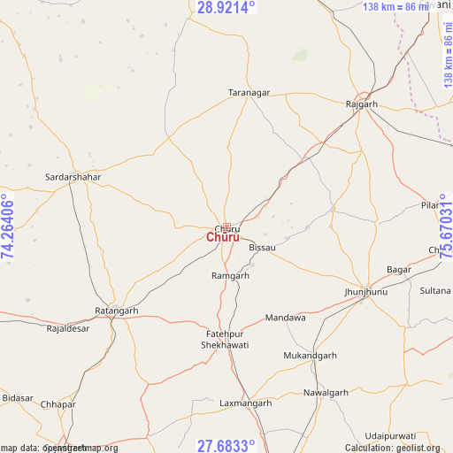
Chūru GPS coordinates[2]
28° 18' 14.94" North, 74° 58' 1.848" East
| Map corner | latitude | longitude |
|---|---|---|
| Upper-left | 28.9214°, | 74.26406° |
| Center: | 28.30415°, | 74.96718° |
| Lower-right: | 27.6833°, | 75.67031° |
| Map W x H: | 137.7×137.7 km | = 85.6×85.6mi |
| max Lat: | 34.9274° ⇑14% North |
| Chūru: | 28.30415° |
| min Lat: | ⇓86% South 8.09008° |
| min Long | Chūru | max Long |
| 68.82655° | 74.96718° | 96.81° |
| W 17%⇐ | ⇒83% E |
Elevation
Elevation of Chūru is 291 m = 955 ft, and this is 4.6 m = 15 ft below average elevation for this country.
| Max E: |
3681 m = 12077 ft | 34.3% |
| Avg. | 295.6 m = 970 ft | |
| Chūru | 291 m = 955 ft | |
Min E: |
1 m = 3 ft | 65.7% |
See also: Chūru elevation on elevation.city.
Geographical zone
Chūru is located in North temperate zone (between Tropic of Cancer and the Arctic Circle). Distance of this Northern Tropic circle is 541.2 km =336.3 mi to South.| Distance of | km | miles | from Chūru |
|---|---|---|---|
| North Pole | 6859.9 | 4262.5 | to North |
| Arctic Circle | 4254 | 2643.3 | to North |
| Tropic Cancer | 541.2 | 336.3 | to South |
| Equator | 3147.1 | 1955.5 | to South |


Nearby cities:
15 places around Chūru: (largest is in red/bold)
• Bagar
53.8 km =33.4 mi,  103°
103°
• Bhuma
58 km =36 mi,  183°
183°
• Bhādāsar
66.3 km =41.2 mi,  271°
271°
• Bissāu
12.4 km =7.7 mi,  120°
120°
• Chidawa
66.3 km =41.2 mi, 96°
• Fatehpur
34.4 km =21.4 mi, 181°
• Jhunjhunūn
46.6 km =29 mi, 115°
• Lachhmangarh Sīkar
53.8 km =33.4 mi,  173°
173°
• Nawalgarh
58.6 km =36.4 mi,  149°
149°
• Pilāni
62.7 km =39 mi,  83°
83°
• Ratangarh
42.2 km =26.2 mi,  234°
234°
• Rājaldesar
57.2 km =35.5 mi,  237°
237°
• Rājgarh
55.6 km =34.5 mi,  47°
47°
• Sardārshahr
49 km =30.4 mi,  288°
288°
• Tārānagar
41 km =25.5 mi,  8°
8°
Sources, notices
• [Note1] Compared only with cities in India existing in our database
• [Src1] Map data: © OpenStreetMap contributors (CC-BY-SA)
• [Src2] Other city data from geonames.org with taken over terms of usage.
• [Src3] Geographical zone / Annual Mean Temperature by Robert A. Rohde @ Wikipedia
