Lachhmangarh Sīkar geodata
Lachhmangarh Sīkar (Rajasthan) is a populated place; located in India in Asia/Kolkata (GMT+5.5) time zone. With population of 48,142 people, there are 912 cities with bigger population in this country. Compared to other cities in India, 83.7% of cities are located further ↓South; 82.6% of cities are located further →East and 73.4% of cities have lower elevation than Lachhmangarh Sīkar. Note1


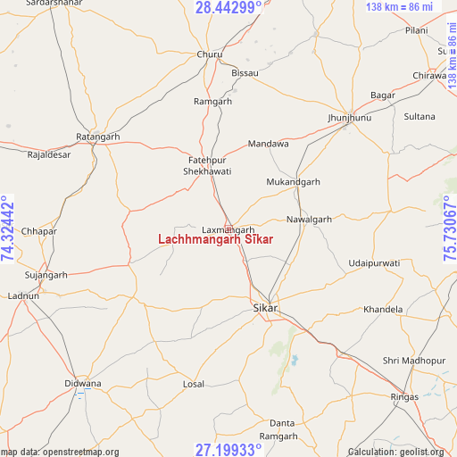
Lachhmangarh Sīkar GPS coordinates[2]
27° 49' 22.584" North, 75° 1' 39.144" East
| Map corner | latitude | longitude |
|---|---|---|
| Upper-left | 28.44299°, | 74.32442° |
| Center: | 27.82294°, | 75.02754° |
| Lower-right: | 27.19933°, | 75.73067° |
| Map W x H: | 138.3×138.3 km | = 85.9×85.9mi |
| max Lat: | 34.9274° ⇑16.3% North |
| Lachhmangarh Sīkar: | 27.82294° |
| min Lat: | ⇓83.7% South 8.09008° |
| min Long | Lachhmangarh S� | max Long |
| 68.82655° | 75.02754° | 96.81° |
| W 17.4%⇐ | ⇒82.6% E |
Elevation
Elevation of Lachhmangarh Sīkar is 365 m = 1198 ft, and this is 69.4 m = 228 ft above average elevation for this country.
| Max E: |
3681 m = 12077 ft | 26.6% |
| Lachhmangarh Sīkar | 365 m 1198 ft | |
| Avg. | 295.6 m = 970 ft | |
Min E: |
1 m = 3 ft | 73.4% |
See also: Lachhmangarh Sīkar elevation on elevation.city.
Geographical zone
Lachhmangarh Sīkar is located in North temperate zone (between Tropic of Cancer and the Arctic Circle). Distance of this Northern Tropic circle is 487.7 km =303 mi to South.| Distance of | km | miles | from Lachhmangarh Sīkar |
|---|---|---|---|
| North Pole | 6913.4 | 4295.8 | to North |
| Arctic Circle | 4307.6 | 2676.6 | to North |
| Tropic Cancer | 487.7 | 303 | to South |
| Equator | 3093.6 | 1922.3 | to South |


Nearby cities:
15 places around Lachhmangarh Sīkar: (largest is in red/bold)
• Bhuma
10.3 km =6.4 mi,  244°
244°
• Bissāu
47.4 km =29.5 mi,  5°
5°
• Chhāpar
57.8 km =35.9 mi,  269°
269°
• Chūru
53.8 km =33.4 mi,  353°
353°
• Fatehpur
20.4 km =12.7 mi,  339°
339°
• Jhunjhunūn
49.6 km =30.8 mi,  47°
47°
• Khandela
52.6 km =32.7 mi,  117°
117°
• Losal
48.3 km =30 mi,  193°
193°
• Meethari Marwar
43.4 km =27 mi,  230°
230°
• Nawalgarh
24.4 km =15.2 mi,  82°
82°
• Ratangarh
49.4 km =30.7 mi,  305°
305°
• Rājaldesar
59 km =36.7 mi,  292°
292°
• Sīkar
25.9 km =16.1 mi,  154°
154°
• Sūjāngarh
56.9 km =35.4 mi,  256°
256°
• Udaipur
45.1 km =28 mi,  104°
104°
Sources, notices
• [Note1] Compared only with cities in India existing in our database
• [Src1] Map data: © OpenStreetMap contributors (CC-BY-SA)
• [Src2] Other city data from geonames.org with taken over terms of usage.
• [Src3] Geographical zone / Annual Mean Temperature by Robert A. Rohde @ Wikipedia
