Rambha geodata
Rambha (Odisha) is a populated place; located in India in Asia/Kolkata (GMT+5.5) time zone. With population of 11,276 people, there are 2806 cities with bigger population in this country. Compared to other cities in India, 66.9% of cities are located further ↑North; 84.6% of cities are located further ←West and 100% of cities have higher elevation than Rambha. Note1


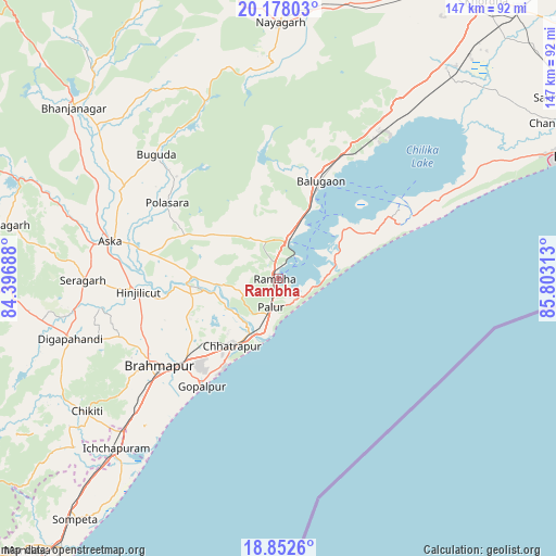
Rambha GPS coordinates[2]
19° 31' 0.012" North, 85° 6' 0" East
| Map corner | latitude | longitude |
|---|---|---|
| Upper-left | 20.17803°, | 84.39688° |
| Center: | 19.51667°, | 85.1° |
| Lower-right: | 18.8526°, | 85.80313° |
| Map W x H: | 147.4×147.4 km | = 91.6×91.6mi |
| max Lat: | 34.9274° ⇑66.9% North |
| Rambha: | 19.51667° |
| min Lat: | ⇓33.1% South 8.09008° |
| min Long | Rambha | max Long |
| 68.82655° | 85.1° | 96.81° |
| W 84.6%⇐ | ⇒15.4% E |
Elevation
Elevation of Rambha is 1 m = 3 ft, and this is 294.6 m = 967 ft below average elevation for this country.
| Max E: |
3681 m = 12077 ft | 100% |
| Avg. | 295.6 m = 970 ft | |
| Rambha | 1 m = 3 ft | |
Min E: |
1 m = 3 ft | 0% |
See also: India elevation on elevation.city.
Geographical zone
Rambha is located in North Torrid zone (between Equator and Tropic of Cancer). Distance of this Northern Tropic circle is 435.9 km =270.9 mi to North.| Distance of | km | miles | from Rambha |
|---|---|---|---|
| North Pole | 7837 | 4869.7 | to North |
| Arctic Circle | 5231.1 | 3250.5 | to North |
| Tropic Cancer | 435.9 | 270.9 | to North |
| Equator | 2170.1 | 1348.4 | to South |


Nearby cities:
15 places around Rambha: (largest is in red/bold)
• Brahmapur
39.5 km =24.5 mi,  234°
234°
• Buguda
45.8 km =28.5 mi,  315°
315°
• Bānapur
30.1 km =18.7 mi,  14°
14°
• Chatrapur
21.7 km =13.5 mi,  214°
214°
• Chikitigarh
61.8 km =38.4 mi,  235°
235°
• Digapahandi
57.6 km =35.8 mi,  253°
253°
• Ganjām
15.3 km =9.5 mi,  199°
199°
• Gopālpur
35.2 km =21.9 mi,  215°
215°
• Hinjilikatu
37.4 km =23.2 mi,  264°
264°
• Ichchāpuram
62.3 km =38.7 mi, 224°
• Khallikot
10.4 km =6.5 mi,  351°
351°
• Kodala
20.5 km =12.7 mi,  305°
305°
• Polasara
35.9 km =22.3 mi,  303°
303°
• Purushottampur
22.5 km =14 mi,  271°
271°
• Āsika
47.3 km =29.4 mi,  282°
282°
Sources, notices
• [Note1] Compared only with cities in India existing in our database
• [Src1] Map data: © OpenStreetMap contributors (CC-BY-SA)
• [Src2] Other city data from geonames.org with taken over terms of usage.
• [Src3] Geographical zone / Annual Mean Temperature by Robert A. Rohde @ Wikipedia
