Polavaram geodata
Polavaram (Andhra Pradesh) is a populated place; located in India in Asia/Kolkata (GMT+5.5) time zone. With population of 43,710 people, there are 1011 cities with bigger population in this country. Compared to other cities in India, 74.3% of cities are located further ↑North; 75.3% of cities are located further ←West and 84.7% of cities have higher elevation than Polavaram. Note1


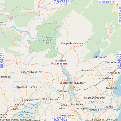
Polavaram GPS coordinates[2]
17° 14' 51.144" North, 81° 38' 37.392" East
| Map corner | latitude | longitude |
|---|---|---|
| Upper-left | 17.91781°, | 80.9406° |
| Center: | 17.24754°, | 81.64372° |
| Lower-right: | 16.57482°, | 82.34685° |
| Map W x H: | 149.3×149.3 km | = 92.8×92.8mi |
| max Lat: | 34.9274° ⇑74.3% North |
| Polavaram: | 17.24754° |
| min Lat: | ⇓25.7% South 8.09008° |
| min Long | Polavaram | max Long |
| 68.82655° | 81.64372° | 96.81° |
| W 75.3%⇐ | ⇒24.7% E |
Elevation
Elevation of Polavaram is 31 m = 102 ft, and this is 264.6 m = 868 ft below average elevation for this country.
| Max E: |
3681 m = 12077 ft | 84.7% |
| Avg. | 295.6 m = 970 ft | |
| Polavaram | 31 m = 102 ft | |
Min E: |
1 m = 3 ft | 15.3% |
See also: Polavaram elevation on elevation.city.
Geographical zone
Polavaram is located in North Torrid zone (between Equator and Tropic of Cancer). Distance of this Northern Tropic circle is 688.2 km =427.6 mi to North.| Distance of | km | miles | from Polavaram |
|---|---|---|---|
| North Pole | 8089.3 | 5026.5 | to North |
| Arctic Circle | 5483.4 | 3407.2 | to North |
| Tropic Cancer | 688.2 | 427.6 | to North |
| Equator | 1917.7 | 1191.6 | to South |


Nearby cities:
15 places around Polavaram: (largest is in red/bold)
• Attili
61.1 km =38 mi,  184°
184°
• Gokavaram
21.9 km =13.6 mi,  86°
86°
• Kovvūr
27.3 km =17 mi,  160°
160°
• Mandapeta
52.5 km =32.6 mi,  144°
144°
• Nidadavole
38.1 km =23.7 mi, 175°
• Peddāpuram
55.9 km =34.7 mi,  109°
109°
• Pippara
59.9 km =37.2 mi,  189°
189°
• Pithāpuram
66.3 km =41.2 mi,  102°
102°
• Rampachodavaram
25.7 km =16 mi,  33°
33°
• Rājahmundry
30.5 km =19 mi,  152°
152°
• Rāmachandrapuram
61.4 km =38.2 mi, 138°
• Sāmalkot
60.4 km =37.5 mi, 110°
• Tanuku
55 km =34.2 mi, 175°
• Tādepallegūdem
49.7 km =30.9 mi, 194°
• vadlamuru
58 km =36 mi, 106°
Sources, notices
• [Note1] Compared only with cities in India existing in our database
• [Src1] Map data: © OpenStreetMap contributors (CC-BY-SA)
• [Src2] Other city data from geonames.org with taken over terms of usage.
• [Src3] Geographical zone / Annual Mean Temperature by Robert A. Rohde @ Wikipedia
