Gokavaram geodata
Gokavaram (Andhra Pradesh) is a populated place; located in India in Asia/Kolkata (GMT+5.5) time zone. With population of 16,389 people, there are 2341 cities with bigger population in this country. Compared to other cities in India, 74.2% of cities are located further ↑North; 76% of cities are located further ←West and 77% of cities have higher elevation than Gokavaram. Note1


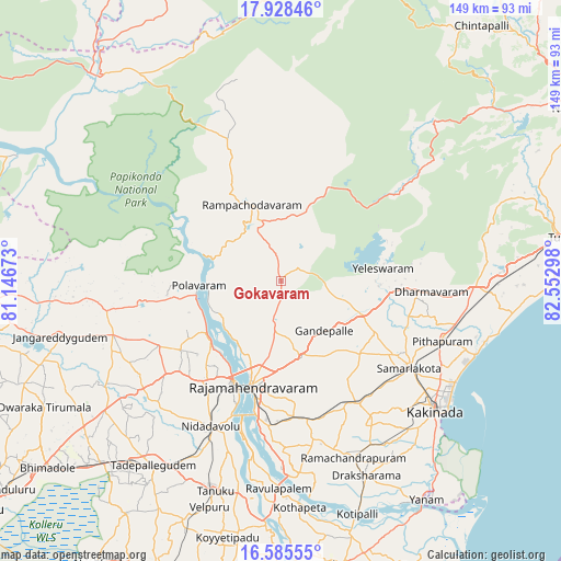
Gokavaram GPS coordinates[2]
17° 15' 29.628" North, 81° 50' 59.46" East
| Map corner | latitude | longitude |
|---|---|---|
| Upper-left | 17.92846°, | 81.14673° |
| Center: | 17.25823°, | 81.84985° |
| Lower-right: | 16.58555°, | 82.55298° |
| Map W x H: | 149.3×149.3 km | = 92.8×92.8mi |
| max Lat: | 34.9274° ⇑74.2% North |
| Gokavaram: | 17.25823° |
| min Lat: | ⇓25.8% South 8.09008° |
| min Long | Gokavaram | max Long |
| 68.82655° | 81.84985° | 96.81° |
| W 76%⇐ | ⇒24% E |
Elevation
Elevation of Gokavaram is 59 m = 194 ft, and this is 236.6 m = 776 ft below average elevation for this country.
| Max E: |
3681 m = 12077 ft | 77% |
| Avg. | 295.6 m = 970 ft | |
| Gokavaram | 59 m = 194 ft | |
Min E: |
1 m = 3 ft | 23% |
See also: India elevation on elevation.city.
Geographical zone
Gokavaram is located in North Torrid zone (between Equator and Tropic of Cancer). Distance of this Northern Tropic circle is 687 km =426.9 mi to North.| Distance of | km | miles | from Gokavaram |
|---|---|---|---|
| North Pole | 8088.1 | 5025.7 | to North |
| Arctic Circle | 5482.2 | 3406.5 | to North |
| Tropic Cancer | 687 | 426.9 | to North |
| Equator | 1918.9 | 1192.3 | to South |


Nearby cities:
15 places around Gokavaram: (largest is in red/bold)
• Kovvūr
29.8 km =18.5 mi,  205°
205°
• Kākināda
52.9 km =32.9 mi,  128°
128°
• Mandapeta
44.8 km =27.8 mi,  169°
169°
• Nidadavole
43.5 km =27 mi, 205°
• Peddāpuram
36.7 km =22.8 mi,  123°
123°
• Pithāpuram
45.6 km =28.3 mi,  110°
110°
• Polavaram
21.9 km =13.6 mi,  266°
266°
• Ramanayyapeta
54 km =33.6 mi, 130°
• Rampachodavaram
21.8 km =13.5 mi,  338°
338°
• Rājahmundry
29.2 km =18.1 mi,  195°
195°
• Rāmachandrapuram
50.6 km =31.4 mi,  157°
157°
• Sāmalkot
41.3 km =25.7 mi, 122°
• Tanuku
58.8 km =36.5 mi, 197°
• Tādepallegūdem
60.1 km =37.3 mi, 214°
• vadlamuru
38.1 km =23.7 mi, 118°
Sources, notices
• [Note1] Compared only with cities in India existing in our database
• [Src1] Map data: © OpenStreetMap contributors (CC-BY-SA)
• [Src2] Other city data from geonames.org with taken over terms of usage.
• [Src3] Geographical zone / Annual Mean Temperature by Robert A. Rohde @ Wikipedia
