Hojāi geodata
Hojāi (Assam) is a seat of a second-order administrative division; located in India in Asia/Kolkata (GMT+5.5) time zone. With population of 36,869 people, there are 1191 cities with bigger population in this country. Compared to other cities in India, 70.3% of cities are located further ↓South; 97.7% of cities are located further ←West and 73.3% of cities have higher elevation than Hojāi. Note1


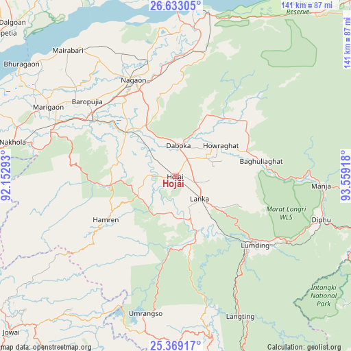
Hojāi GPS coordinates[2]
26° 0' 10.116" North, 92° 51' 21.78" East
| Map corner | latitude | longitude |
|---|---|---|
| Upper-left | 26.63305°, | 92.15293° |
| Center: | 26.00281°, | 92.85605° |
| Lower-right: | 25.36917°, | 93.55918° |
| Map W x H: | 140.5×140.5 km | = 87.3×87.3mi |
| max Lat: | 34.9274° ⇑29.7% North |
| Hojāi: | 26.00281° |
| min Lat: | ⇓70.3% South 8.09008° |
| min Long | Hojāi | max Long |
| 68.82655° | 92.85605° | 96.81° |
| W 97.7%⇐ | ⇒2.3% E |
Elevation
Elevation of Hojāi is 78 m = 256 ft, and this is 217.6 m = 714 ft below average elevation for this country.
| Max E: |
3681 m = 12077 ft | 73.3% |
| Avg. | 295.6 m = 970 ft | |
| Hojāi | 78 m = 256 ft | |
Min E: |
1 m = 3 ft | 26.7% |
See also: India elevation on elevation.city.
Geographical zone
Hojāi is located in North temperate zone (between Tropic of Cancer and the Arctic Circle). Distance of this Northern Tropic circle is 285.3 km =177.3 mi to South.| Distance of | km | miles | from Hojāi |
|---|---|---|---|
| North Pole | 7115.8 | 4421.6 | to North |
| Arctic Circle | 4509.9 | 2802.3 | to North |
| Tropic Cancer | 285.3 | 177.3 | to South |
| Equator | 2891.2 | 1796.5 | to South |


Nearby cities:
15 places around Hojāi: (largest is in red/bold)
• Biswanath Chariali
85.4 km =53.1 mi,  19°
19°
• Bokajān
92.3 km =57.4 mi,  88°
88°
• Dhekiajuli
86.6 km =53.8 mi,  334°
334°
• Dhing
64.3 km =40 mi,  323°
323°
• Dimāpur
87.1 km =54.1 mi,  96°
96°
• Diphu
60.2 km =37.4 mi,  107°
107°
• Hamren
25.1 km =15.6 mi,  252°
252°
• Hāflong
94.6 km =58.8 mi,  170°
170°
• Khliehriat
86.9 km =54 mi,  214°
214°
• Khārupatia
91 km =56.5 mi,  309°
309°
• Lumding Railway Colony
42.2 km =26.2 mi,  131°
131°
• Maibong
83 km =51.6 mi,  160°
160°
• Morigaon
57.7 km =35.9 mi,  298°
298°
• Rahā
42.5 km =26.4 mi, 307°
• Tezpur
70.3 km =43.7 mi,  355°
355°
Sources, notices
• [Note1] Compared only with cities in India existing in our database
• [Src1] Map data: © OpenStreetMap contributors (CC-BY-SA)
• [Src2] Other city data from geonames.org with taken over terms of usage.
• [Src3] Geographical zone / Annual Mean Temperature by Robert A. Rohde @ Wikipedia
