Uppiliyapuram geodata
Uppiliyapuram (Tamil Nadu) is a populated place; located in India in Asia/Kolkata (GMT+5.5) time zone. With population of 6,900 people, there are 3221 cities with bigger population in this country. Compared to other cities in India, 92.1% of cities are located further ↑North; 54.3% of cities are located further ←West and 54% of cities have higher elevation than Uppiliyapuram. Note1


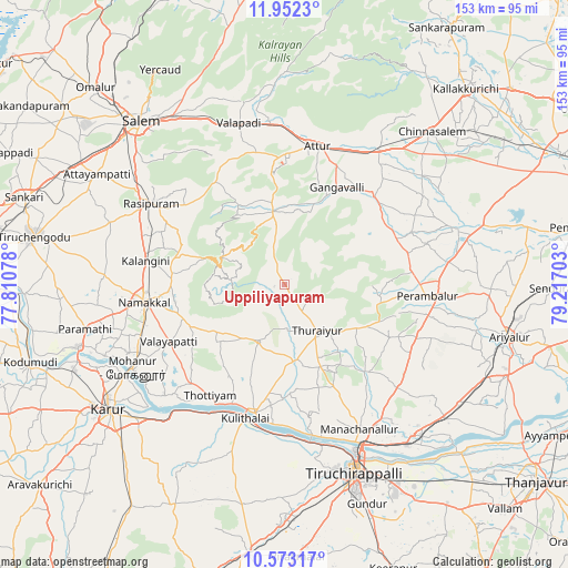
Uppiliyapuram GPS coordinates[2]
11° 15' 48.816" North, 78° 30' 50.04" East
| Map corner | latitude | longitude |
|---|---|---|
| Upper-left | 11.9523°, | 77.81078° |
| Center: | 11.26356°, | 78.5139° |
| Lower-right: | 10.57317°, | 79.21703° |
| Map W x H: | 153.3×153.3 km | = 95.3×95.3mi |
| max Lat: | 34.9274° ⇑92.1% North |
| Uppiliyapuram: | 11.26356° |
| min Lat: | ⇓7.9% South 8.09008° |
| min Long | Uppiliyapuram | max Long |
| 68.82655° | 78.5139° | 96.81° |
| W 54.3%⇐ | ⇒45.7% E |
Elevation
Elevation of Uppiliyapuram is 180 m = 591 ft, and this is 115.6 m = 379 ft below average elevation for this country.
| Max E: |
3681 m = 12077 ft | 54% |
| Avg. | 295.6 m = 970 ft | |
| Uppiliyapuram | 180 m = 591 ft | |
Min E: |
1 m = 3 ft | 46% |
See also: India elevation on elevation.city.
Geographical zone
Uppiliyapuram is located in North Torrid zone (between Equator and Tropic of Cancer). Distance of Equator is 1252.4 km =778.2 mi to South.| Distance of | km | miles | from Uppiliyapuram |
|---|---|---|---|
| North Pole | 8754.7 | 5439.9 | to North |
| Arctic Circle | 6148.8 | 3820.7 | to North |
| Tropic Cancer | 1353.5 | 841 | to North |
| Equator | 1252.4 | 778.2 | to South |


Nearby cities:
15 places around Uppiliyapuram: (largest is in red/bold)
• Arumbāvūr
26.9 km =16.7 mi,  60°
60°
• Attur
38 km =23.6 mi,  14°
14°
• Erumaippatti
27.7 km =17.2 mi,  241°
241°
• Gangavalli
30 km =18.6 mi,  29°
29°
• Kulittalai
38.2 km =23.7 mi,  196°
196°
• Mettuppālaiyam
12.7 km =7.9 mi,  213°
213°
• Musiri
35.4 km =22 mi,  192°
192°
• Nāmagiripettai
34.2 km =21.3 mi,  308°
308°
• Nāmakkal
38.3 km =23.8 mi,  262°
262°
• Perambalur
40.4 km =25.1 mi,  94°
94°
• Puduppatti
35.2 km =21.9 mi,  249°
249°
• Rasipuram
41.9 km =26 mi,  301°
301°
• Turaiyūr
15.7 km =9.8 mi,  143°
143°
• Tāttayyangārpettai
17 km =10.6 mi, 204°
• Vīraganūr
33.8 km =21 mi,  45°
45°
Sources, notices
• [Note1] Compared only with cities in India existing in our database
• [Src1] Map data: © OpenStreetMap contributors (CC-BY-SA)
• [Src2] Other city data from geonames.org with taken over terms of usage.
• [Src3] Geographical zone / Annual Mean Temperature by Robert A. Rohde @ Wikipedia
