Vīraganūr geodata
Vīraganūr (Tamil Nadu) is a populated place; located in India in Asia/Kolkata (GMT+5.5) time zone. With population of 10,854 people, there are 2849 cities with bigger population in this country. Compared to other cities in India, 91.4% of cities are located further ↑North; 56.2% of cities are located further ←West and 55.8% of cities have higher elevation than Vīraganūr. Note1


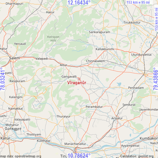
Vīraganūr GPS coordinates[2]
11° 28' 34.068" North, 78° 44' 7.908" East
| Map corner | latitude | longitude |
|---|---|---|
| Upper-left | 12.16434°, | 78.03241° |
| Center: | 11.47613°, | 78.73553° |
| Lower-right: | 10.78624°, | 79.43866° |
| Map W x H: | 153.2×153.2 km | = 95.2×95.2mi |
| max Lat: | 34.9274° ⇑91.4% North |
| Vīraganūr: | 11.47613° |
| min Lat: | ⇓8.6% South 8.09008° |
| min Long | Vīraganūr | max Long |
| 68.82655° | 78.73553° | 96.81° |
| W 56.2%⇐ | ⇒43.8% E |
Elevation
Elevation of Vīraganūr is 171 m = 561 ft, and this is 124.6 m = 409 ft below average elevation for this country.
| Max E: |
3681 m = 12077 ft | 55.8% |
| Avg. | 295.6 m = 970 ft | |
| Vīraganūr | 171 m = 561 ft | |
Min E: |
1 m = 3 ft | 44.2% |
See also: India elevation on elevation.city.
Geographical zone
Vīraganūr is located in North Torrid zone (between Equator and Tropic of Cancer). Distance of Equator is 1276 km =792.9 mi to South.| Distance of | km | miles | from Vīraganūr |
|---|---|---|---|
| North Pole | 8731 | 5425.2 | to North |
| Arctic Circle | 6125.1 | 3806 | to North |
| Tropic Cancer | 1329.9 | 826.4 | to North |
| Equator | 1276 | 792.9 | to South |


Nearby cities:
15 places around Vīraganūr: (largest is in red/bold)
• Alagāpuram
49.8 km =30.9 mi,  23°
23°
• Ariyalūr
52.8 km =32.8 mi,  135°
135°
• Arumbāvūr
10.6 km =6.6 mi,  183°
183°
• Attur
19.6 km =12.2 mi,  311°
311°
• Belūr
43.4 km =27 mi, 306°
• Chinna Salem
23.2 km =14.4 mi,  40°
40°
• Gangavalli
9.7 km =6 mi,  284°
284°
• Kallakkurichchi
38.2 km =23.7 mi, 39°
• Mettuppālaiyam
46.3 km =28.8 mi,  222°
222°
• Māttūr
53.7 km =33.4 mi,  108°
108°
• Nāmagiripettai
51 km =31.7 mi,  267°
267°
• Perambalur
31.4 km =19.5 mi,  149°
149°
• Turaiyūr
39.2 km =24.4 mi,  202°
202°
• Tāttayyangārpettai
50.1 km =31.1 mi, 218°
• Uppiliyapuram
33.8 km =21 mi,  225°
225°
Sources, notices
• [Note1] Compared only with cities in India existing in our database
• [Src1] Map data: © OpenStreetMap contributors (CC-BY-SA)
• [Src2] Other city data from geonames.org with taken over terms of usage.
• [Src3] Geographical zone / Annual Mean Temperature by Robert A. Rohde @ Wikipedia
