Pedana geodata
Pedana (Andhra Pradesh) is a populated place; located in India in Asia/Kolkata (GMT+5.5) time zone. With population of 30,252 people, there are 1433 cities with bigger population in this country. Compared to other cities in India, 77.3% of cities are located further ↑North; 73.5% of cities are located further ←West and 93.5% of cities have higher elevation than Pedana. Note1


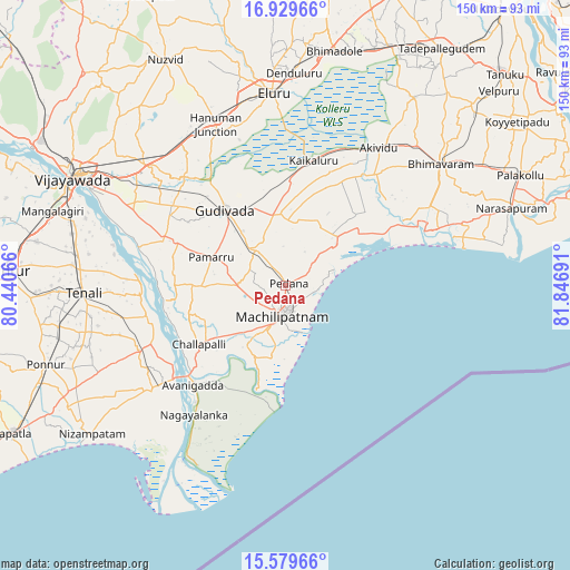
Pedana GPS coordinates[2]
16° 15' 20.952" North, 81° 8' 37.608" East
| Map corner | latitude | longitude |
|---|---|---|
| Upper-left | 16.92966°, | 80.44066° |
| Center: | 16.25582°, | 81.14378° |
| Lower-right: | 15.57966°, | 81.84691° |
| Map W x H: | 150.1×150.1 km | = 93.3×93.3mi |
| max Lat: | 34.9274° ⇑77.3% North |
| Pedana: | 16.25582° |
| min Lat: | ⇓22.7% South 8.09008° |
| min Long | Pedana | max Long |
| 68.82655° | 81.14378° | 96.81° |
| W 73.5%⇐ | ⇒26.5% E |
Elevation
Elevation of Pedana is 13 m = 43 ft, and this is 282.6 m = 927 ft below average elevation for this country.
| Max E: |
3681 m = 12077 ft | 93.5% |
| Avg. | 295.6 m = 970 ft | |
| Pedana | 13 m = 43 ft | |
Min E: |
1 m = 3 ft | 6.5% |
See also: India elevation on elevation.city.
Geographical zone
Pedana is located in North Torrid zone (between Equator and Tropic of Cancer). Distance of this Northern Tropic circle is 798.4 km =496.1 mi to North.| Distance of | km | miles | from Pedana |
|---|---|---|---|
| North Pole | 8199.6 | 5095 | to North |
| Arctic Circle | 5593.7 | 3475.8 | to North |
| Tropic Cancer | 798.4 | 496.1 | to North |
| Equator | 1807.5 | 1123.1 | to South |


Nearby cities:
15 places around Pedana: (largest is in red/bold)
• Akivīdu
44.3 km =27.5 mi,  34°
34°
• Avanigadda
35.5 km =22.1 mi,  222°
222°
• Bhattiprolu
42.3 km =26.3 mi,  246°
246°
• Challapalle
27.4 km =17 mi,  235°
235°
• Gannavaram
48.3 km =30 mi,  311°
311°
• Gudivāda
25.5 km =15.8 mi,  321°
321°
• Gudlavalleru
14.5 km =9 mi, 316°
• Kaikalūr
33.7 km =20.9 mi,  12°
12°
• Kankipādu
44.9 km =27.9 mi,  296°
296°
• Kanuru
12.3 km =7.6 mi,  74°
74°
• Korukollu
29.4 km =18.3 mi,  22°
22°
• Machilīpatnam
7.6 km =4.7 mi,  183°
183°
• Pallevāda
39.3 km =24.4 mi, 24°
• Repalle
42.7 km =26.5 mi,  231°
231°
• Vuyyūru
34.1 km =21.2 mi,  290°
290°
Sources, notices
• [Note1] Compared only with cities in India existing in our database
• [Src1] Map data: © OpenStreetMap contributors (CC-BY-SA)
• [Src2] Other city data from geonames.org with taken over terms of usage.
• [Src3] Geographical zone / Annual Mean Temperature by Robert A. Rohde @ Wikipedia
