Machilīpatnam geodata
Machilīpatnam (Andhra Pradesh) is a populated place; located in India in Asia/Kolkata (GMT+5.5) time zone. With population of 192,827 people, there are 221 cities with bigger population in this country. Compared to other cities in India, 77.5% of cities are located further ↑North; 73.4% of cities are located further ←West and 95.4% of cities have higher elevation than Machilīpatnam. Note1


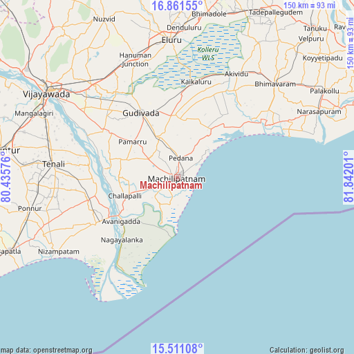
Machilīpatnam GPS coordinates[2]
16° 11' 14.892" North, 81° 8' 19.968" East
| Map corner | latitude | longitude |
|---|---|---|
| Upper-left | 16.86155°, | 80.43576° |
| Center: | 16.18747°, | 81.13888° |
| Lower-right: | 15.51108°, | 81.84201° |
| Map W x H: | 150.2×150.2 km | = 93.3×93.3mi |
| max Lat: | 34.9274° ⇑77.5% North |
| Machilīpatnam: | 16.18747° |
| min Lat: | ⇓22.5% South 8.09008° |
| min Long | Machilīpatnam | max Long |
| 68.82655° | 81.13888° | 96.81° |
| W 73.4%⇐ | ⇒26.6% E |
Elevation
Elevation of Machilīpatnam is 11 m = 36 ft, and this is 284.6 m = 934 ft below average elevation for this country.
| Max E: |
3681 m = 12077 ft | 95.4% |
| Avg. | 295.6 m = 970 ft | |
| Machilīpatnam | 11 m = 36 ft | |
Min E: |
1 m = 3 ft | 4.6% |
See also: Machilīpatnam elevation on elevation.city.
Geographical zone
Machilīpatnam is located in North Torrid zone (between Equator and Tropic of Cancer). Distance of this Northern Tropic circle is 806 km =500.8 mi to North.| Distance of | km | miles | from Machilīpatnam |
|---|---|---|---|
| North Pole | 8207.2 | 5099.7 | to North |
| Arctic Circle | 5601.3 | 3480.5 | to North |
| Tropic Cancer | 806 | 500.8 | to North |
| Equator | 1799.9 | 1118.4 | to South |


Nearby cities:
15 places around Machilīpatnam: (largest is in red/bold)
• Akivīdu
50.9 km =31.6 mi,  30°
30°
• Avanigadda
29.9 km =18.6 mi,  231°
231°
• Bhattiprolu
39.4 km =24.5 mi,  256°
256°
• Challapalle
23.5 km =14.6 mi,  250°
250°
• Gannavaram
53.2 km =33.1 mi,  317°
317°
• Gudivāda
31.5 km =19.6 mi,  330°
330°
• Gudlavalleru
20.4 km =12.7 mi, 332°
• Kaikalūr
41.3 km =25.7 mi,  11°
11°
• Kankipādu
48.3 km =30 mi,  304°
304°
• Kanuru
16.5 km =10.3 mi,  48°
48°
• Korukollu
36.7 km =22.8 mi,  18°
18°
• Pallevāda
46.5 km =28.9 mi, 20°
• Pedana
7.6 km =4.7 mi,  3°
3°
• Repalle
38 km =23.6 mi,  240°
240°
• Vuyyūru
37 km =23 mi, 301°
Sources, notices
• [Note1] Compared only with cities in India existing in our database
• [Src1] Map data: © OpenStreetMap contributors (CC-BY-SA)
• [Src2] Other city data from geonames.org with taken over terms of usage.
• [Src3] Geographical zone / Annual Mean Temperature by Robert A. Rohde @ Wikipedia
