Ellore geodata
Ellore (Andhra Pradesh) is a populated place; located in India in Asia/Kolkata (GMT+5.5) time zone. With population of 183,387 people, there are 230 cities with bigger population in this country. Compared to other cities in India, 75.7% of cities are located further ↑North; 73.3% of cities are located further ←West and 88.9% of cities have higher elevation than Ellore. Note1


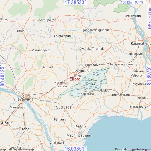
Ellore GPS coordinates[2]
16° 42' 47.196" North, 81° 6' 15.732" East
| Map corner | latitude | longitude |
|---|---|---|
| Upper-left | 17.38533°, | 80.40125° |
| Center: | 16.71311°, | 81.10437° |
| Lower-right: | 16.03851°, | 81.8075° |
| Map W x H: | 149.8×149.8 km | = 93.1×93.1mi |
| max Lat: | 34.9274° ⇑75.7% North |
| Ellore: | 16.71311° |
| min Lat: | ⇓24.3% South 8.09008° |
| min Long | Ellore | max Long |
| 68.82655° | 81.10437° | 96.81° |
| W 73.3%⇐ | ⇒26.7% E |
Elevation
Elevation of Ellore is 20 m = 66 ft, and this is 275.6 m = 904 ft below average elevation for this country.
| Max E: |
3681 m = 12077 ft | 88.9% |
| Avg. | 295.6 m = 970 ft | |
| Ellore | 20 m = 66 ft | |
Min E: |
1 m = 3 ft | 11.1% |
See also: Ellore elevation on elevation.city.
Geographical zone
Ellore is located in North Torrid zone (between Equator and Tropic of Cancer). Distance of this Northern Tropic circle is 747.6 km =464.5 mi to North.| Distance of | km | miles | from Ellore |
|---|---|---|---|
| North Pole | 8148.7 | 5063.4 | to North |
| Arctic Circle | 5542.9 | 3444.2 | to North |
| Tropic Cancer | 747.6 | 464.5 | to North |
| Equator | 1858.3 | 1154.7 | to South |


Nearby cities:
15 places around Ellore: (largest is in red/bold)
• Akivīdu
32.9 km =20.4 mi,  116°
116°
• Bhīmavaram
48.6 km =30.2 mi,  113°
113°
• Gannavaram
37.5 km =23.3 mi,  239°
239°
• Gudivāda
33 km =20.5 mi,  200°
200°
• Gudlavalleru
40.8 km =25.4 mi,  188°
188°
• Kaikalūr
21.4 km =13.3 mi,  146°
146°
• Kankipādu
47.4 km =29.5 mi,  229°
229°
• Kanuru
50.1 km =31.1 mi,  161°
161°
• Korukollu
28.3 km =17.6 mi, 146°
• Nūzvīd
28.8 km =17.9 mi,  286°
286°
• Pallevāda
25.2 km =15.7 mi,  126°
126°
• Pedana
51 km =31.7 mi,  175°
175°
• Pippara
47.5 km =29.5 mi,  89°
89°
• Tādepallegūdem
46.4 km =28.8 mi,  75°
75°
• Vuyyūru
47.8 km =29.7 mi,  215°
215°
Sources, notices
• [Note1] Compared only with cities in India existing in our database
• [Src1] Map data: © OpenStreetMap contributors (CC-BY-SA)
• [Src2] Other city data from geonames.org with taken over terms of usage.
• [Src3] Geographical zone / Annual Mean Temperature by Robert A. Rohde @ Wikipedia
