Chittūr geodata
Chittūr (Kerala) is a populated place; located in India in Asia/Kolkata (GMT+5.5) time zone. With population of 31,608 people, there are 1373 cities with bigger population in this country. Compared to other cities in India, 94.4% of cities are located further ↑North; 65.7% of cities are located further →East and 62.3% of cities have higher elevation than Chittūr. Note1


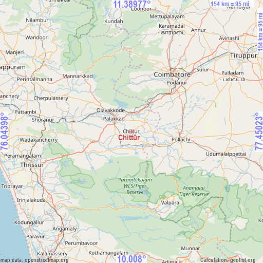
Chittūr GPS coordinates[2]
10° 41' 58.812" North, 76° 44' 49.56" East
| Map corner | latitude | longitude |
|---|---|---|
| Upper-left | 11.38977°, | 76.04398° |
| Center: | 10.69967°, | 76.7471° |
| Lower-right: | 10.008°, | 77.45023° |
| Map W x H: | 153.6×153.6 km | = 95.4×95.4mi |
| max Lat: | 34.9274° ⇑94.4% North |
| Chittūr: | 10.69967° |
| min Lat: | ⇓5.6% South 8.09008° |
| min Long | Chittūr | max Long |
| 68.82655° | 76.7471° | 96.81° |
| W 34.3%⇐ | ⇒65.7% E |
Elevation
Elevation of Chittūr is 136 m = 446 ft, and this is 159.6 m = 524 ft below average elevation for this country.
| Max E: |
3681 m = 12077 ft | 62.3% |
| Avg. | 295.6 m = 970 ft | |
| Chittūr | 136 m = 446 ft | |
Min E: |
1 m = 3 ft | 37.7% |
See also: India elevation on elevation.city.
Geographical zone
Chittūr is located in North Torrid zone (between Equator and Tropic of Cancer). Distance of Equator is 1189.7 km =739.2 mi to South.| Distance of | km | miles | from Chittūr |
|---|---|---|---|
| North Pole | 8817.4 | 5478.9 | to North |
| Arctic Circle | 6211.5 | 3859.6 | to North |
| Tropic Cancer | 1416.2 | 880 | to North |
| Equator | 1189.7 | 739.2 | to South |


Nearby cities:
15 places around Chittūr: (largest is in red/bold)
• Anamalais
24.2 km =15 mi,  122°
122°
• Chettipālaiyam
39.5 km =24.5 mi,  53°
53°
• Chēlakara
44.1 km =27.4 mi,  269°
269°
• Coimbatore
41.6 km =25.8 mi,  35°
35°
• Irugūr
49.4 km =30.7 mi, 44°
• Madukkarai
32.9 km =20.4 mi, 45°
• Mannārakkāt
44.9 km =27.9 mi,  316°
316°
• Ottappālam
41.2 km =25.6 mi,  281°
281°
• Periyanegamam
39.2 km =24.4 mi,  82°
82°
• Perūr
35.6 km =22.1 mi,  30°
30°
• Pollachi
28.9 km =18 mi,  99°
99°
• Pālghāt
13.1 km =8.1 mi,  308°
308°
• Singānallūr
45.6 km =28.3 mi, 43°
• Valparai
47.1 km =29.3 mi,  151°
151°
• Vettaikkaranpudur
23.7 km =14.7 mi,  130°
130°
Sources, notices
• [Note1] Compared only with cities in India existing in our database
• [Src1] Map data: © OpenStreetMap contributors (CC-BY-SA)
• [Src2] Other city data from geonames.org with taken over terms of usage.
• [Src3] Geographical zone / Annual Mean Temperature by Robert A. Rohde @ Wikipedia
