Orai geodata
Orai (Uttar Pradesh) is a populated place; located in India in Asia/Kolkata (GMT+5.5) time zone. With population of 158,265 people, there are 276 cities with bigger population in this country. Compared to other cities in India, 70.2% of cities are located further ↓South; 63.3% of cities are located further ←West and 61.3% of cities have higher elevation than Orai. Note1


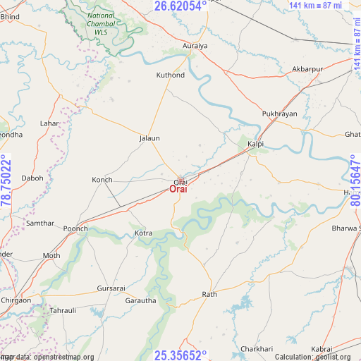
Orai GPS coordinates[2]
25° 59' 24.828" North, 79° 27' 12.024" East
| Map corner | latitude | longitude |
|---|---|---|
| Upper-left | 26.62054°, | 78.75022° |
| Center: | 25.99023°, | 79.45334° |
| Lower-right: | 25.35652°, | 80.15647° |
| Map W x H: | 140.5×140.5 km | = 87.3×87.3mi |
| max Lat: | 34.9274° ⇑29.8% North |
| Orai: | 25.99023° |
| min Lat: | ⇓70.2% South 8.09008° |
| min Long | Orai | max Long |
| 68.82655° | 79.45334° | 96.81° |
| W 63.3%⇐ | ⇒36.7% E |
Elevation
Elevation of Orai is 141 m = 463 ft, and this is 154.6 m = 507 ft below average elevation for this country.
| Max E: |
3681 m = 12077 ft | 61.3% |
| Avg. | 295.6 m = 970 ft | |
| Orai | 141 m = 463 ft | |
Min E: |
1 m = 3 ft | 38.7% |
See also: Orai elevation on elevation.city.
Geographical zone
Orai is located in North temperate zone (between Tropic of Cancer and the Arctic Circle). Distance of this Northern Tropic circle is 283.9 km =176.4 mi to South.| Distance of | km | miles | from Orai |
|---|---|---|---|
| North Pole | 7117.2 | 4422.4 | to North |
| Arctic Circle | 4511.3 | 2803.2 | to North |
| Tropic Cancer | 283.9 | 176.4 | to South |
| Equator | 2889.8 | 1795.6 | to South |


Nearby cities:
15 places around Orai: (largest is in red/bold)
• Garautha
49.1 km =30.5 mi,  198°
198°
• Gohānd
33.7 km =20.9 mi,  164°
164°
• Gursarāi
49.7 km =30.9 mi,  213°
213°
• Jālaun
20.8 km =12.9 mi,  325°
325°
• Kadaura
38.5 km =23.9 mi,  90°
90°
• Konch
30.2 km =18.8 mi,  270°
270°
• Kotra
24.9 km =15.5 mi,  215°
215°
• Kālpi
31.3 km =19.4 mi,  63°
63°
• Mādhogarh
41.4 km =25.7 mi,  319°
319°
• Nadīgaon
44.9 km =27.9 mi,  286°
286°
• Pukhrāyān
46.3 km =28.8 mi, 55°
• Rāmpura
48.3 km =30 mi, 325°
• Rāth
45.4 km =28.2 mi,  165°
165°
• Sarīla
32.6 km =20.3 mi,  137°
137°
• Sikandra
45.5 km =28.3 mi,  22°
22°
Sources, notices
• [Note1] Compared only with cities in India existing in our database
• [Src1] Map data: © OpenStreetMap contributors (CC-BY-SA)
• [Src2] Other city data from geonames.org with taken over terms of usage.
• [Src3] Geographical zone / Annual Mean Temperature by Robert A. Rohde @ Wikipedia
