Sarīla geodata
Sarīla (Uttar Pradesh) is a populated place; located in India in Asia/Kolkata (GMT+5.5) time zone. With population of 8,012 people, there are 3125 cities with bigger population in this country. Compared to other cities in India, 68.9% of cities are located further ↓South; 65.5% of cities are located further ←West and 60.1% of cities have higher elevation than Sarīla. Note1


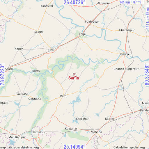
Sarīla GPS coordinates[2]
25° 46' 32.844" North, 79° 40' 31.26" East
| Map corner | latitude | longitude |
|---|---|---|
| Upper-left | 26.40726°, | 78.97223° |
| Center: | 25.77579°, | 79.67535° |
| Lower-right: | 25.14094°, | 80.37848° |
| Map W x H: | 140.8×140.8 km | = 87.5×87.5mi |
| max Lat: | 34.9274° ⇑31.1% North |
| Sarīla: | 25.77579° |
| min Lat: | ⇓68.9% South 8.09008° |
| min Long | Sarīla | max Long |
| 68.82655° | 79.67535° | 96.81° |
| W 65.5%⇐ | ⇒34.5% E |
Elevation
Elevation of Sarīla is 148 m = 486 ft, and this is 147.6 m = 484 ft below average elevation for this country.
| Max E: |
3681 m = 12077 ft | 60.1% |
| Avg. | 295.6 m = 970 ft | |
| Sarīla | 148 m = 486 ft | |
Min E: |
1 m = 3 ft | 39.9% |
See also: India elevation on elevation.city.
Geographical zone
Sarīla is located in North temperate zone (between Tropic of Cancer and the Arctic Circle). Distance of this Northern Tropic circle is 260.1 km =161.6 mi to South.| Distance of | km | miles | from Sarīla |
|---|---|---|---|
| North Pole | 7141.1 | 4437.3 | to North |
| Arctic Circle | 4535.2 | 2818 | to North |
| Tropic Cancer | 260.1 | 161.6 | to South |
| Equator | 2866 | 1780.8 | to South |


Nearby cities:
15 places around Sarīla: (largest is in red/bold)
• Charkhāri
42.1 km =26.2 mi,  169°
169°
• Garautha
44.1 km =27.4 mi,  239°
239°
• Gohānd
15.6 km =9.7 mi, 236°
• Gursarāi
52.6 km =32.7 mi,  250°
250°
• Hamīrpur
51.4 km =31.9 mi,  67°
67°
• Kadaura
28.4 km =17.6 mi,  34°
34°
• Kharela
29.3 km =18.2 mi,  152°
152°
• Kotra
36.8 km =22.9 mi,  275°
275°
• Kulpahār
50.8 km =31.6 mi,  184°
184°
• Kurāra
38.8 km =24.1 mi,  54°
54°
• Kālpi
38.3 km =23.8 mi,  8°
8°
• Maudaha
45.1 km =28 mi,  103°
103°
• Orai
32.6 km =20.3 mi,  317°
317°
• Pukhrāyān
52.4 km =32.6 mi,  18°
18°
• Rāth
22.9 km =14.2 mi,  208°
208°
Sources, notices
• [Note1] Compared only with cities in India existing in our database
• [Src1] Map data: © OpenStreetMap contributors (CC-BY-SA)
• [Src2] Other city data from geonames.org with taken over terms of usage.
• [Src3] Geographical zone / Annual Mean Temperature by Robert A. Rohde @ Wikipedia
