Rāth geodata
Rāth (Uttar Pradesh) is a populated place; located in India in Asia/Kolkata (GMT+5.5) time zone. With population of 61,728 people, there are 711 cities with bigger population in this country. Compared to other cities in India, 67.6% of cities are located further ↓South; 64.4% of cities are located further ←West and 55.8% of cities have higher elevation than Rāth. Note1


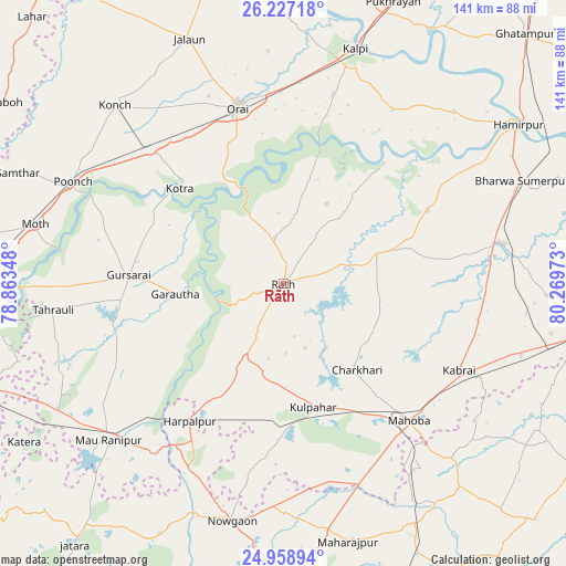
Rāth GPS coordinates[2]
25° 35' 41.064" North, 79° 33' 59.76" East
| Map corner | latitude | longitude |
|---|---|---|
| Upper-left | 26.22718°, | 78.86348° |
| Center: | 25.59474°, | 79.5666° |
| Lower-right: | 24.95894°, | 80.26973° |
| Map W x H: | 141×141 km | = 87.6×87.6mi |
| max Lat: | 34.9274° ⇑32.4% North |
| Rāth: | 25.59474° |
| min Lat: | ⇓67.6% South 8.09008° |
| min Long | Rāth | max Long |
| 68.82655° | 79.5666° | 96.81° |
| W 64.4%⇐ | ⇒35.6% E |
Elevation
Elevation of Rāth is 171 m = 561 ft, and this is 124.6 m = 409 ft below average elevation for this country.
| Max E: |
3681 m = 12077 ft | 55.8% |
| Avg. | 295.6 m = 970 ft | |
| Rāth | 171 m = 561 ft | |
Min E: |
1 m = 3 ft | 44.2% |
See also: Rāth elevation on elevation.city.
Geographical zone
Rāth is located in North temperate zone (between Tropic of Cancer and the Arctic Circle). Distance of this Northern Tropic circle is 239.9 km =149.1 mi to South.| Distance of | km | miles | from Rāth |
|---|---|---|---|
| North Pole | 7161.2 | 4449.8 | to North |
| Arctic Circle | 4555.3 | 2830.5 | to North |
| Tropic Cancer | 239.9 | 149.1 | to South |
| Equator | 2845.9 | 1768.4 | to South |


Nearby cities:
15 places around Rāth: (largest is in red/bold)
• Charkhāri
28.1 km =17.5 mi,  139°
139°
• Garautha
27.1 km =16.8 mi,  264°
264°
• Gohānd
11.7 km =7.3 mi,  349°
349°
• Gursarāi
38.8 km =24.1 mi,  273°
273°
• Harpālpur
41.4 km =25.7 mi,  214°
214°
• Kabrāi
48.4 km =30.1 mi,  116°
116°
• Kadaura
51.3 km =31.9 mi,  32°
32°
• Kharela
25.3 km =15.7 mi,  103°
103°
• Kotra
35 km =21.7 mi,  312°
312°
• Kulpahār
31.4 km =19.5 mi,  166°
166°
• Mahobā
45.9 km =28.5 mi, 137°
• Maudaha
55.8 km =34.7 mi,  79°
79°
• Orai
45.4 km =28.2 mi, 345°
• Sarīla
22.9 km =14.2 mi, 28°
• Tori-Fatehpur
48 km =29.8 mi,  251°
251°
Sources, notices
• [Note1] Compared only with cities in India existing in our database
• [Src1] Map data: © OpenStreetMap contributors (CC-BY-SA)
• [Src2] Other city data from geonames.org with taken over terms of usage.
• [Src3] Geographical zone / Annual Mean Temperature by Robert A. Rohde @ Wikipedia
