Nadīgaon geodata
Nadīgaon (Uttar Pradesh) is a populated place; located in India in Asia/Kolkata (GMT+5.5) time zone. With population of 7,597 people, there are 3163 cities with bigger population in this country. Compared to other cities in India, 71.2% of cities are located further ↓South; 59.2% of cities are located further ←West and 60.3% of cities have higher elevation than Nadīgaon. Note1


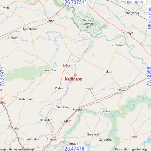
Nadīgaon GPS coordinates[2]
26° 6' 28.224" North, 79° 1' 22.188" East
| Map corner | latitude | longitude |
|---|---|---|
| Upper-left | 26.73751°, | 78.31971° |
| Center: | 26.10784°, | 79.02283° |
| Lower-right: | 25.47476°, | 79.72596° |
| Map W x H: | 140.4×140.4 km | = 87.2×87.2mi |
| max Lat: | 34.9274° ⇑28.8% North |
| Nadīgaon: | 26.10784° |
| min Lat: | ⇓71.2% South 8.09008° |
| min Long | Nadīgaon | max Long |
| 68.82655° | 79.02283° | 96.81° |
| W 59.2%⇐ | ⇒40.8% E |
Elevation
Elevation of Nadīgaon is 147 m = 482 ft, and this is 148.6 m = 488 ft below average elevation for this country.
| Max E: |
3681 m = 12077 ft | 60.3% |
| Avg. | 295.6 m = 970 ft | |
| Nadīgaon | 147 m = 482 ft | |
Min E: |
1 m = 3 ft | 39.7% |
See also: India elevation on elevation.city.
Geographical zone
Nadīgaon is located in North temperate zone (between Tropic of Cancer and the Arctic Circle). Distance of this Northern Tropic circle is 297 km =184.5 mi to South.| Distance of | km | miles | from Nadīgaon |
|---|---|---|---|
| North Pole | 7104.1 | 4414.3 | to North |
| Arctic Circle | 4498.3 | 2795.1 | to North |
| Tropic Cancer | 297 | 184.5 | to South |
| Equator | 2902.9 | 1803.8 | to South |


Nearby cities:
15 places around Nadīgaon: (largest is in red/bold)
• Alampur
24.4 km =15.2 mi,  247°
247°
• Daboh
18.7 km =11.6 mi,  231°
231°
• Jālaun
31.6 km =19.6 mi,  82°
82°
• Konch
18 km =11.2 mi,  134°
134°
• Kotra
44 km =27.3 mi,  139°
139°
• Lahār
12.6 km =7.8 mi,  319°
319°
• Mau
39.2 km =24.4 mi,  296°
296°
• Mihona
20 km =12.4 mi,  347°
347°
• Moth
43.1 km =26.8 mi,  189°
189°
• Mādhogarh
24.7 km =15.3 mi,  41°
41°
• Orai
44.9 km =27.9 mi,  106°
106°
• Rāmpura
31.2 km =19.4 mi,  30°
30°
• Samthar
31.6 km =19.6 mi,  201°
201°
• Seondha
24.7 km =15.3 mi,  282°
282°
• Umri
45.6 km =28.3 mi, 349°
Sources, notices
• [Note1] Compared only with cities in India existing in our database
• [Src1] Map data: © OpenStreetMap contributors (CC-BY-SA)
• [Src2] Other city data from geonames.org with taken over terms of usage.
• [Src3] Geographical zone / Annual Mean Temperature by Robert A. Rohde @ Wikipedia
