Garautha geodata
Garautha (Uttar Pradesh) is a populated place; located in India in Asia/Kolkata (GMT+5.5) time zone. With population of 9,489 people, there are 2994 cities with bigger population in this country. Compared to other cities in India, 67.4% of cities are located further ↓South; 61.8% of cities are located further ←West and 58.6% of cities have higher elevation than Garautha. Note1


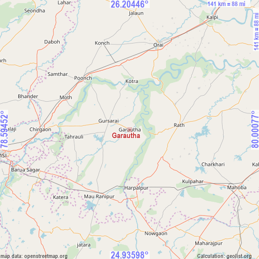
Garautha GPS coordinates[2]
25° 34' 18.84" North, 79° 17' 51.504" East
| Map corner | latitude | longitude |
|---|---|---|
| Upper-left | 26.20446°, | 78.59452° |
| Center: | 25.5719°, | 79.29764° |
| Lower-right: | 24.93598°, | 80.00077° |
| Map W x H: | 141×141 km | = 87.6×87.6mi |
| max Lat: | 34.9274° ⇑32.6% North |
| Garautha: | 25.5719° |
| min Lat: | ⇓67.4% South 8.09008° |
| min Long | Garautha | max Long |
| 68.82655° | 79.29764° | 96.81° |
| W 61.8%⇐ | ⇒38.2% E |
Elevation
Elevation of Garautha is 155 m = 509 ft, and this is 140.6 m = 461 ft below average elevation for this country.
| Max E: |
3681 m = 12077 ft | 58.6% |
| Avg. | 295.6 m = 970 ft | |
| Garautha | 155 m = 509 ft | |
Min E: |
1 m = 3 ft | 41.4% |
See also: India elevation on elevation.city.
Geographical zone
Garautha is located in North temperate zone (between Tropic of Cancer and the Arctic Circle). Distance of this Northern Tropic circle is 237.4 km =147.5 mi to South.| Distance of | km | miles | from Garautha |
|---|---|---|---|
| North Pole | 7163.7 | 4451.3 | to North |
| Arctic Circle | 4557.8 | 2832.1 | to North |
| Tropic Cancer | 237.4 | 147.5 | to South |
| Equator | 2843.3 | 1766.7 | to South |


Nearby cities:
15 places around Garautha: (largest is in red/bold)
• Charkhāri
49 km =30.4 mi,  112°
112°
• Chirgaon
48.5 km =30.1 mi,  270°
270°
• Gohānd
28.6 km =17.8 mi,  60°
60°
• Gursarāi
12.8 km =8 mi,  293°
293°
• Harpālpur
31.8 km =19.8 mi,  173°
173°
• Konch
49.2 km =30.6 mi,  342°
342°
• Kotra
26.2 km =16.3 mi,  2°
2°
• Kulpahār
44.3 km =27.5 mi,  129°
129°
• Moth
38.8 km =24.1 mi,  296°
296°
• Orai
49.1 km =30.5 mi,  18°
18°
• Rānīpur
42.9 km =26.7 mi,  213°
213°
• Rāth
27.1 km =16.8 mi,  84°
84°
• Samthar
49.4 km =30.7 mi,  307°
307°
• Sarīla
44.1 km =27.4 mi, 59°
• Tori-Fatehpur
22.5 km =14 mi,  234°
234°
Sources, notices
• [Note1] Compared only with cities in India existing in our database
• [Src1] Map data: © OpenStreetMap contributors (CC-BY-SA)
• [Src2] Other city data from geonames.org with taken over terms of usage.
• [Src3] Geographical zone / Annual Mean Temperature by Robert A. Rohde @ Wikipedia
