Mādhogarh geodata
Mādhogarh (Uttar Pradesh) is a populated place; located in India in Asia/Kolkata (GMT+5.5) time zone. With population of 10,530 people, there are 2888 cities with bigger population in this country. Compared to other cities in India, 72.8% of cities are located further ↓South; 60.9% of cities are located further ←West and 59.9% of cities have higher elevation than Mādhogarh. Note1


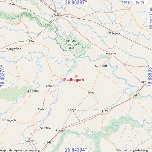
Mādhogarh GPS coordinates[2]
26° 16' 30.792" North, 79° 11' 9.24" East
| Map corner | latitude | longitude |
|---|---|---|
| Upper-left | 26.90397°, | 78.48278° |
| Center: | 26.27522°, | 79.1859° |
| Lower-right: | 25.64304°, | 79.88903° |
| Map W x H: | 140.2×140.2 km | = 87.1×87.1mi |
| max Lat: | 34.9274° ⇑27.2% North |
| Mādhogarh: | 26.27522° |
| min Lat: | ⇓72.8% South 8.09008° |
| min Long | Mādhogarh | max Long |
| 68.82655° | 79.1859° | 96.81° |
| W 60.9%⇐ | ⇒39.1% E |
Elevation
Elevation of Mādhogarh is 149 m = 489 ft, and this is 146.6 m = 481 ft below average elevation for this country.
| Max E: |
3681 m = 12077 ft | 59.9% |
| Avg. | 295.6 m = 970 ft | |
| Mādhogarh | 149 m = 489 ft | |
Min E: |
1 m = 3 ft | 40.1% |
See also: India elevation on elevation.city.
Geographical zone
Mādhogarh is located in North temperate zone (between Tropic of Cancer and the Arctic Circle). Distance of this Northern Tropic circle is 315.6 km =196.1 mi to South.| Distance of | km | miles | from Mādhogarh |
|---|---|---|---|
| North Pole | 7085.5 | 4402.7 | to North |
| Arctic Circle | 4479.6 | 2783.5 | to North |
| Tropic Cancer | 315.6 | 196.1 | to South |
| Equator | 2921.5 | 1815.3 | to South |


Nearby cities:
15 places around Mādhogarh: (largest is in red/bold)
• Auraiya
38.5 km =23.9 mi,  56°
56°
• Bakewar
43 km =26.7 mi,  358°
358°
• Daboh
43.3 km =26.9 mi,  225°
225°
• Jālaun
20.9 km =13 mi,  133°
133°
• Konch
31.4 km =19.5 mi,  186°
186°
• Lahār
26 km =16.2 mi,  249°
249°
• Lakhnā
41.6 km =25.8 mi,  354°
354°
• Mihona
20.5 km =12.7 mi,  272°
272°
• Nadīgaon
24.7 km =15.3 mi,  221°
221°
• Orai
41.4 km =25.7 mi,  139°
139°
• Phaphūnd
45.4 km =28.2 mi,  37°
37°
• Rāmpura
8.3 km =5.2 mi, 357°
• Seondha
42.6 km =26.5 mi, 251°
• Sikandra
45.4 km =28.2 mi,  76°
76°
• Umri
36.1 km =22.4 mi,  316°
316°
Sources, notices
• [Note1] Compared only with cities in India existing in our database
• [Src1] Map data: © OpenStreetMap contributors (CC-BY-SA)
• [Src2] Other city data from geonames.org with taken over terms of usage.
• [Src3] Geographical zone / Annual Mean Temperature by Robert A. Rohde @ Wikipedia
