Ankleshwar geodata
Ankleshwar (Gujarat) is a populated place; located in India in Asia/Kolkata (GMT+5.5) time zone. With population of 74,742 people, there are 586 cities with bigger population in this country. Compared to other cities in India, 58.4% of cities are located further ↑North; 94.8% of cities are located further →East and 88.1% of cities have higher elevation than Ankleshwar. Note1


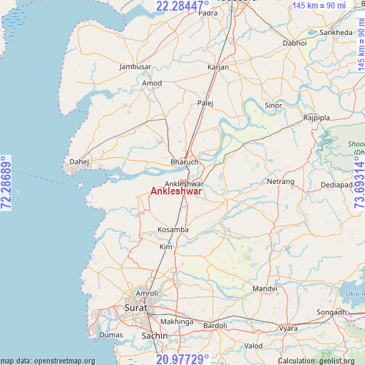
Ankleshwar GPS coordinates[2]
21° 37' 56.496" North, 72° 59' 24.036" East
| Map corner | latitude | longitude |
|---|---|---|
| Upper-left | 22.28447°, | 72.28689° |
| Center: | 21.63236°, | 72.99001° |
| Lower-right: | 20.97729°, | 73.69314° |
| Map W x H: | 145.3×145.3 km | = 90.3×90.3mi |
| max Lat: | 34.9274° ⇑58.4% North |
| Ankleshwar: | 21.63236° |
| min Lat: | ⇓41.6% South 8.09008° |
| min Long | Ankleshwar | max Long |
| 68.82655° | 72.99001° | 96.81° |
| W 5.2%⇐ | ⇒94.8% E |
Elevation
Elevation of Ankleshwar is 22 m = 72 ft, and this is 273.6 m = 898 ft below average elevation for this country.
| Max E: |
3681 m = 12077 ft | 88.1% |
| Avg. | 295.6 m = 970 ft | |
| Ankleshwar | 22 m = 72 ft | |
Min E: |
1 m = 3 ft | 11.9% |
See also: Ankleshwar elevation on elevation.city.
Geographical zone
Ankleshwar is located in North Torrid zone (between Equator and Tropic of Cancer). Distance of this Northern Tropic circle is 200.6 km =124.6 mi to North.| Distance of | km | miles | from Ankleshwar |
|---|---|---|---|
| North Pole | 7601.8 | 4723.5 | to North |
| Arctic Circle | 4995.9 | 3104.3 | to North |
| Tropic Cancer | 200.6 | 124.6 | to North |
| Equator | 2405.3 | 1494.6 | to South |


Nearby cities:
15 places around Ankleshwar: (largest is in red/bold)
• Amod
42 km =26.1 mi,  342°
342°
• Amroli
45.2 km =28.1 mi,  200°
200°
• Bharūch
7 km =4.3 mi,  351°
351°
• Bārdoli
58 km =36 mi,  167°
167°
• Hansot
19.6 km =12.2 mi,  254°
254°
• Jambusar
50.6 km =31.4 mi, 337°
• Kadod
51.9 km =32.2 mi,  152°
152°
• Kosamba
19.2 km =11.9 mi,  189°
189°
• Kāthor
38.6 km =24 mi, 187°
• Māndvi
53.1 km =33 mi,  142°
142°
• Olpād
41.1 km =25.5 mi,  216°
216°
• Rājpīpla
58.8 km =36.5 mi,  63°
63°
• Sinor
47.6 km =29.6 mi,  49°
49°
• Sūrat
51.3 km =31.9 mi, 198°
• Utrān
46.2 km =28.7 mi, 196°
Sources, notices
• [Note1] Compared only with cities in India existing in our database
• [Src1] Map data: © OpenStreetMap contributors (CC-BY-SA)
• [Src2] Other city data from geonames.org with taken over terms of usage.
• [Src3] Geographical zone / Annual Mean Temperature by Robert A. Rohde @ Wikipedia
