Bharūch geodata
Bharūch (Gujarat) is a populated place; located in India in Asia/Kolkata (GMT+5.5) time zone. With population of 153,528 people, there are 284 cities with bigger population in this country. Compared to other cities in India, 58% of cities are located further ↑North; 94.8% of cities are located further →East and 94.3% of cities have higher elevation than Bharūch. Note1


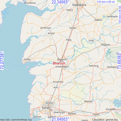
Bharūch GPS coordinates[2]
21° 41' 41.352" North, 72° 58' 49.8" East
| Map corner | latitude | longitude |
|---|---|---|
| Upper-left | 22.34665°, | 72.27738° |
| Center: | 21.69482°, | 72.9805° |
| Lower-right: | 21.04003°, | 73.68363° |
| Map W x H: | 145.3×145.3 km | = 90.3×90.3mi |
| max Lat: | 34.9274° ⇑58% North |
| Bharūch: | 21.69482° |
| min Lat: | ⇓42% South 8.09008° |
| min Long | Bharūch | max Long |
| 68.82655° | 72.9805° | 96.81° |
| W 5.2%⇐ | ⇒94.8% E |
Elevation
Elevation of Bharūch is 12 m = 39 ft, and this is 283.6 m = 930 ft below average elevation for this country.
| Max E: |
3681 m = 12077 ft | 94.3% |
| Avg. | 295.6 m = 970 ft | |
| Bharūch | 12 m = 39 ft | |
Min E: |
1 m = 3 ft | 5.7% |
See also: Bharūch elevation on elevation.city.
Geographical zone
Bharūch is located in North Torrid zone (between Equator and Tropic of Cancer). Distance of this Northern Tropic circle is 193.7 km =120.4 mi to North.| Distance of | km | miles | from Bharūch |
|---|---|---|---|
| North Pole | 7594.8 | 4719.2 | to North |
| Arctic Circle | 4988.9 | 3100 | to North |
| Tropic Cancer | 193.7 | 120.4 | to North |
| Equator | 2412.2 | 1498.9 | to South |


Nearby cities:
15 places around Bharūch: (largest is in red/bold)
• Amod
35.1 km =21.8 mi,  341°
341°
• Amroli
51.5 km =32 mi,  196°
196°
• Ankleshwar
7 km =4.3 mi,  171°
171°
• Hansot
21.6 km =13.4 mi,  235°
235°
• Jambusar
43.9 km =27.3 mi,  334°
334°
• Kadod
58.6 km =36.4 mi,  155°
155°
• Kosamba
26 km =16.2 mi,  185°
185°
• Kāthor
45.4 km =28.2 mi, 185°
• Māndvi
59.2 km =36.8 mi,  145°
145°
• Olpād
46.3 km =28.8 mi,  210°
210°
• Padra
61.5 km =38.2 mi,  10°
10°
• Rājpīpla
56.9 km =35.4 mi,  70°
70°
• Sinor
44.2 km =27.5 mi,  57°
57°
• Sūrat
57.6 km =35.8 mi, 195°
• Utrān
52.6 km =32.7 mi, 192°
Sources, notices
• [Note1] Compared only with cities in India existing in our database
• [Src1] Map data: © OpenStreetMap contributors (CC-BY-SA)
• [Src2] Other city data from geonames.org with taken over terms of usage.
• [Src3] Geographical zone / Annual Mean Temperature by Robert A. Rohde @ Wikipedia
