Hansot geodata
Hansot (Gujarat) is a populated place; located in India in Asia/Kolkata (GMT+5.5) time zone. With population of 12,525 people, there are 2697 cities with bigger population in this country. Compared to other cities in India, 58.6% of cities are located further ↑North; 95.9% of cities are located further →East and 91.1% of cities have higher elevation than Hansot. Note1


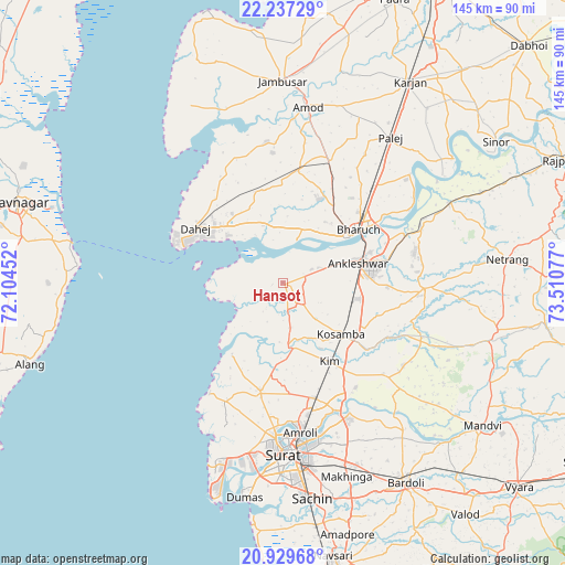
Hansot GPS coordinates[2]
21° 35' 5.856" North, 72° 48' 27.504" East
| Map corner | latitude | longitude |
|---|---|---|
| Upper-left | 22.23729°, | 72.10452° |
| Center: | 21.58496°, | 72.80764° |
| Lower-right: | 20.92968°, | 73.51077° |
| Map W x H: | 145.4×145.4 km | = 90.3×90.3mi |
| max Lat: | 34.9274° ⇑58.6% North |
| Hansot: | 21.58496° |
| min Lat: | ⇓41.4% South 8.09008° |
| min Long | Hansot | max Long |
| 68.82655° | 72.80764° | 96.81° |
| W 4.1%⇐ | ⇒95.9% E |
Elevation
Elevation of Hansot is 16 m = 52 ft, and this is 279.6 m = 917 ft below average elevation for this country.
| Max E: |
3681 m = 12077 ft | 91.1% |
| Avg. | 295.6 m = 970 ft | |
| Hansot | 16 m = 52 ft | |
Min E: |
1 m = 3 ft | 8.9% |
See also: India elevation on elevation.city.
Geographical zone
Hansot is located in North Torrid zone (between Equator and Tropic of Cancer). Distance of this Northern Tropic circle is 205.9 km =127.9 mi to North.| Distance of | km | miles | from Hansot |
|---|---|---|---|
| North Pole | 7607 | 4726.8 | to North |
| Arctic Circle | 5001.2 | 3107.6 | to North |
| Tropic Cancer | 205.9 | 127.9 | to North |
| Equator | 2400 | 1491.3 | to South |


Nearby cities:
15 places around Hansot: (largest is in red/bold)
• Amod
45.8 km =28.5 mi,  8°
8°
• Amroli
37.3 km =23.2 mi,  175°
175°
• Ankleshwar
19.6 km =12.2 mi,  74°
74°
• Bharūch
21.6 km =13.4 mi,  55°
55°
• Bārdoli
60.2 km =37.4 mi,  148°
148°
• Ghogha
56.1 km =34.9 mi,  281°
281°
• Jambusar
52 km =32.3 mi,  359°
359°
• Kadod
59.1 km =36.7 mi,  133°
133°
• Kosamba
20.7 km =12.9 mi, 131°
• Kāthor
35.7 km =22.2 mi,  157°
157°
• Māndvi
63.1 km =39.2 mi, 125°
• Olpād
28.2 km =17.5 mi,  191°
191°
• Sachīn
55.9 km =34.7 mi,  172°
172°
• Sūrat
43.3 km =26.9 mi, 176°
• Utrān
39.6 km =24.6 mi, 171°
Sources, notices
• [Note1] Compared only with cities in India existing in our database
• [Src1] Map data: © OpenStreetMap contributors (CC-BY-SA)
• [Src2] Other city data from geonames.org with taken over terms of usage.
• [Src3] Geographical zone / Annual Mean Temperature by Robert A. Rohde @ Wikipedia
