Nilakottai geodata
Nilakottai (Tamil Nadu) is a populated place; located in India in Asia/Kolkata (GMT+5.5) time zone. With population of 21,683 people, there are 1922 cities with bigger population in this country. Compared to other cities in India, 95.8% of cities are located further ↑North; 53.1% of cities are located further →East and 55.6% of cities have lower elevation than Nilakottai. Note1


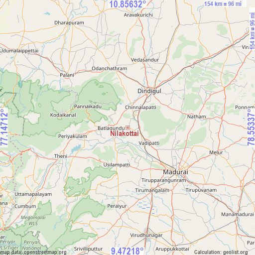
Nilakottai GPS coordinates[2]
10° 9' 54" North, 77° 51' 0.864" East
| Map corner | latitude | longitude |
|---|---|---|
| Upper-left | 10.85632°, | 77.14712° |
| Center: | 10.165°, | 77.85024° |
| Lower-right: | 9.47218°, | 78.55337° |
| Map W x H: | 153.9×153.9 km | = 95.6×95.6mi |
| max Lat: | 34.9274° ⇑95.8% North |
| Nilakottai: | 10.165° |
| min Lat: | ⇓4.2% South 8.09008° |
| min Long | Nilakottai | max Long |
| 68.82655° | 77.85024° | 96.81° |
| W 46.9%⇐ | ⇒53.1% E |
Elevation
Elevation of Nilakottai is 228 m = 748 ft, and this is 67.6 m = 222 ft below average elevation for this country.
| Max E: |
3681 m = 12077 ft | 44.4% |
| Avg. | 295.6 m = 970 ft | |
| Nilakottai | 228 m = 748 ft | |
Min E: |
1 m = 3 ft | 55.6% |
See also: India elevation on elevation.city.
Geographical zone
Nilakottai is located in North Torrid zone (between Equator and Tropic of Cancer). Distance of Equator is 1130.2 km =702.3 mi to South.| Distance of | km | miles | from Nilakottai |
|---|---|---|---|
| North Pole | 8876.8 | 5515.8 | to North |
| Arctic Circle | 6270.9 | 3896.6 | to North |
| Tropic Cancer | 1475.7 | 917 | to North |
| Equator | 1130.2 | 702.3 | to South |


Nearby cities:
15 places around Nilakottai: (largest is in red/bold)
• Alangānallūr
29.4 km =18.3 mi,  116°
116°
• Devadānappatti
22.7 km =14.1 mi,  264°
264°
• Dindigul
26.8 km =16.7 mi,  32°
32°
• Elumalai
37.2 km =23.1 mi,  206°
206°
• Kodaikānāl
40.3 km =25 mi,  281°
281°
• Madurai
40.2 km =25 mi,  132°
132°
• Periyakulam
33.9 km =21.1 mi, 262°
• Pālamedu
29.6 km =18.4 mi,  103°
103°
• Tirupparangunram
39.9 km =24.8 mi,  142°
142°
• Usilampatti
22.9 km =14.2 mi,  197°
197°
• V.S.K.Valasai (Dindigul-Dist.)
37 km =23 mi,  63°
63°
• Vadamadurai
40.9 km =25.4 mi,  41°
41°
• Vattalkundu
10 km =6.2 mi,  267°
267°
• Vādippatti
15.1 km =9.4 mi, 126°
• Āndippatti
31.2 km =19.4 mi,  233°
233°
Sources, notices
• [Note1] Compared only with cities in India existing in our database
• [Src1] Map data: © OpenStreetMap contributors (CC-BY-SA)
• [Src2] Other city data from geonames.org with taken over terms of usage.
• [Src3] Geographical zone / Annual Mean Temperature by Robert A. Rohde @ Wikipedia
