Tirupparangunram geodata
Tirupparangunram (Tamil Nadu) is a populated place; located in India in Asia/Kolkata (GMT+5.5) time zone. With population of 42,696 people, there are 1033 cities with bigger population in this country. Compared to other cities in India, 96.7% of cities are located further ↑North; 50.6% of cities are located further →East and 58.7% of cities have higher elevation than Tirupparangunram. Note1


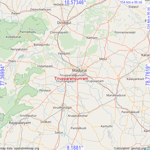
Tirupparangunram GPS coordinates[2]
9° 52' 53.436" North, 78° 4' 23.016" East
| Map corner | latitude | longitude |
|---|---|---|
| Upper-left | 10.57346°, | 77.36994° |
| Center: | 9.88151°, | 78.07306° |
| Lower-right: | 9.1881°, | 78.77619° |
| Map W x H: | 154×154 km | = 95.7×95.7mi |
| max Lat: | 34.9274° ⇑96.7% North |
| Tirupparangunram: | 9.88151° |
| min Lat: | ⇓3.3% South 8.09008° |
| min Long | Tirupparangunra | max Long |
| 68.82655° | 78.07306° | 96.81° |
| W 49.4%⇐ | ⇒50.6% E |
Elevation
Elevation of Tirupparangunram is 154 m = 505 ft, and this is 141.6 m = 465 ft below average elevation for this country.
| Max E: |
3681 m = 12077 ft | 58.7% |
| Avg. | 295.6 m = 970 ft | |
| Tirupparangunram | 154 m = 505 ft | |
Min E: |
1 m = 3 ft | 41.3% |
See also: Tirupparangunram elevation on elevation.city.
Geographical zone
Tirupparangunram is located in North Torrid zone (between Equator and Tropic of Cancer). Distance of Equator is 1098.7 km =682.7 mi to South.| Distance of | km | miles | from Tirupparangunram |
|---|---|---|---|
| North Pole | 8908.3 | 5535.4 | to North |
| Arctic Circle | 6302.5 | 3916.2 | to North |
| Tropic Cancer | 1507.2 | 936.5 | to North |
| Equator | 1098.7 | 682.7 | to South |


Nearby cities:
15 places around Tirupparangunram: (largest is in red/bold)
• Alangānallūr
18.5 km =11.5 mi,  5°
5°
• Aruppukkottai
41.4 km =25.7 mi,  176°
176°
• Elumalai
41 km =25.5 mi,  267°
267°
• Kallupatti
29.1 km =18.1 mi,  230°
230°
• Kariapatti
23.1 km =14.4 mi,  172°
172°
• Madurai
6.6 km =4.1 mi,  50°
50°
• Melur
33.6 km =20.9 mi,  60°
60°
• Nattam
42.1 km =26.2 mi,  24°
24°
• Nilakottai
39.9 km =24.8 mi,  322°
322°
• Peraiyur
35 km =21.7 mi,  242°
242°
• Pālamedu
25.2 km =15.7 mi, 10°
• Tiruppuvanam
21.2 km =13.2 mi,  107°
107°
• Usilampatti
32.9 km =20.4 mi,  287°
287°
• Virudunagar
35.3 km =21.9 mi,  200°
200°
• Vādippatti
25.7 km =16 mi,  331°
331°
Sources, notices
• [Note1] Compared only with cities in India existing in our database
• [Src1] Map data: © OpenStreetMap contributors (CC-BY-SA)
• [Src2] Other city data from geonames.org with taken over terms of usage.
• [Src3] Geographical zone / Annual Mean Temperature by Robert A. Rohde @ Wikipedia
