Vadamadurai geodata
Vadamadurai (Tamil Nadu) is a populated place; located in India in Asia/Kolkata (GMT+5.5) time zone. With population of 15,886 people, there are 2378 cities with bigger population in this country. Compared to other cities in India, 95.2% of cities are located further ↑North; 50.2% of cities are located further →East and 66% of cities have lower elevation than Vadamadurai. Note1


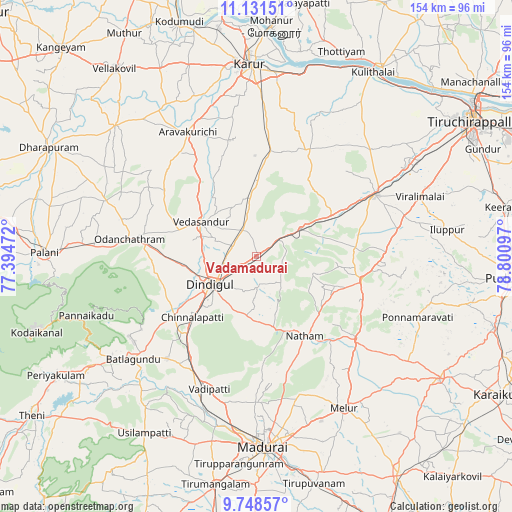
Vadamadurai GPS coordinates[2]
10° 26' 26.916" North, 78° 5' 52.224" East
| Map corner | latitude | longitude |
|---|---|---|
| Upper-left | 11.13151°, | 77.39472° |
| Center: | 10.44081°, | 78.09784° |
| Lower-right: | 9.74857°, | 78.80097° |
| Map W x H: | 153.8×153.8 km | = 95.6×95.6mi |
| max Lat: | 34.9274° ⇑95.2% North |
| Vadamadurai: | 10.44081° |
| min Lat: | ⇓4.8% South 8.09008° |
| min Long | Vadamadurai | max Long |
| 68.82655° | 78.09784° | 96.81° |
| W 49.8%⇐ | ⇒50.2% E |
Elevation
Elevation of Vadamadurai is 293 m = 961 ft, and this is 2.6 m = 9 ft below average elevation for this country.
| Max E: |
3681 m = 12077 ft | 34% |
| Avg. | 295.6 m = 970 ft | |
| Vadamadurai | 293 m = 961 ft | |
Min E: |
1 m = 3 ft | 66% |
See also: India elevation on elevation.city.
Geographical zone
Vadamadurai is located in North Torrid zone (between Equator and Tropic of Cancer). Distance of Equator is 1160.9 km =721.3 mi to South.| Distance of | km | miles | from Vadamadurai |
|---|---|---|---|
| North Pole | 8846.2 | 5496.8 | to North |
| Arctic Circle | 6240.3 | 3877.5 | to North |
| Tropic Cancer | 1445 | 897.9 | to North |
| Equator | 1160.9 | 721.3 | to South |


Nearby cities:
15 places around Vadamadurai: (largest is in red/bold)
• Alangānallūr
43.8 km =27.2 mi,  181°
181°
• Dindigul
15.1 km =9.4 mi,  238°
238°
• Karur
57.5 km =35.7 mi,  358°
358°
• Manapparai
40.4 km =25.1 mi,  62°
62°
• Melur
52.5 km =32.6 mi,  149°
149°
• Mūlanūr
57.7 km =35.9 mi,  312°
312°
• Nattam
27.7 km =17.2 mi, 148°
• Nilakottai
40.9 km =25.4 mi,  221°
221°
• Pallappatti
39.2 km =24.4 mi,  322°
322°
• Ponnamarāvati
51.1 km =31.8 mi,  110°
110°
• Pālamedu
37.4 km =23.2 mi, 177°
• V.S.K.Valasai (Dindigul-Dist.)
15.1 km =9.4 mi,  157°
157°
• Vattalkundu
48.4 km =30.1 mi,  229°
229°
• Vedasandūr
19 km =11.8 mi,  301°
301°
• Vādippatti
42.3 km =26.3 mi,  200°
200°
Sources, notices
• [Note1] Compared only with cities in India existing in our database
• [Src1] Map data: © OpenStreetMap contributors (CC-BY-SA)
• [Src2] Other city data from geonames.org with taken over terms of usage.
• [Src3] Geographical zone / Annual Mean Temperature by Robert A. Rohde @ Wikipedia
