Madurai geodata
Madurai (Tamil Nadu) is a seat of a second-order administrative division; located in India in Asia/Kolkata (GMT+5.5) time zone. With population of 909,908 people, there are 47 cities with bigger population in this country. Compared to other cities in India, 96.7% of cities are located further ↑North; 50.1% of cities are located further ←West and 61.9% of cities have higher elevation than Madurai. Note1


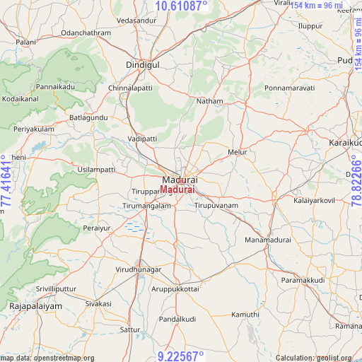
Madurai GPS coordinates[2]
9° 55' 8.4" North, 78° 7' 10.308" East
| Map corner | latitude | longitude |
|---|---|---|
| Upper-left | 10.61087°, | 77.41641° |
| Center: | 9.919°, | 78.11953° |
| Lower-right: | 9.22567°, | 78.82266° |
| Map W x H: | 154×154 km | = 95.7×95.7mi |
| max Lat: | 34.9274° ⇑96.7% North |
| Madurai: | 9.919° |
| min Lat: | ⇓3.3% South 8.09008° |
| min Long | Madurai | max Long |
| 68.82655° | 78.11953° | 96.81° |
| W 50.1%⇐ | ⇒49.9% E |
Elevation
Elevation of Madurai is 138 m = 453 ft, and this is 157.6 m = 517 ft below average elevation for this country.
| Max E: |
3681 m = 12077 ft | 61.9% |
| Avg. | 295.6 m = 970 ft | |
| Madurai | 138 m = 453 ft | |
Min E: |
1 m = 3 ft | 38.1% |
See also: Madurai elevation on elevation.city.
Geographical zone
Madurai is located in North Torrid zone (between Equator and Tropic of Cancer). Distance of Equator is 1102.9 km =685.3 mi to South.| Distance of | km | miles | from Madurai |
|---|---|---|---|
| North Pole | 8904.2 | 5532.8 | to North |
| Arctic Circle | 6298.3 | 3913.6 | to North |
| Tropic Cancer | 1503 | 933.9 | to North |
| Equator | 1102.9 | 685.3 | to South |


Nearby cities:
15 places around Madurai: (largest is in red/bold)
• Alangānallūr
14.6 km =9.1 mi,  347°
347°
• Kallupatti
35.7 km =22.2 mi,  230°
230°
• Kariapatti
27.2 km =16.9 mi,  184°
184°
• Melur
27.2 km =16.9 mi,  62°
62°
• Nattam
36.4 km =22.6 mi,  19°
19°
• Nilakottai
40.2 km =25 mi,  312°
312°
• Peraiyur
41.5 km =25.8 mi,  240°
240°
• Pālamedu
20.7 km =12.9 mi,  358°
358°
• Sivaganga
40.7 km =25.3 mi,  101°
101°
• Tirupparangunram
6.6 km =4.1 mi, 230°
• Tiruppuvanam
18.4 km =11.4 mi,  124°
124°
• Usilampatti
36.9 km =22.9 mi,  278°
278°
• V.S.K.Valasai (Dindigul-Dist.)
44.2 km =27.5 mi,  4°
4°
• Virudunagar
41.1 km =25.5 mi,  205°
205°
• Vādippatti
25.3 km =15.7 mi,  316°
316°
Sources, notices
• [Note1] Compared only with cities in India existing in our database
• [Src1] Map data: © OpenStreetMap contributors (CC-BY-SA)
• [Src2] Other city data from geonames.org with taken over terms of usage.
• [Src3] Geographical zone / Annual Mean Temperature by Robert A. Rohde @ Wikipedia
