Usilampatti geodata
Usilampatti (Tamil Nadu) is a populated place; located in India in Asia/Kolkata (GMT+5.5) time zone. With population of 30,675 people, there are 1414 cities with bigger population in this country. Compared to other cities in India, 96.6% of cities are located further ↑North; 53.9% of cities are located further →East and 52.8% of cities have lower elevation than Usilampatti. Note1


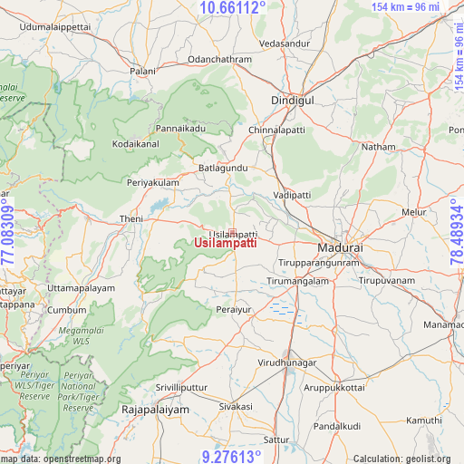
Usilampatti GPS coordinates[2]
9° 58' 9.696" North, 77° 47' 10.356" East
| Map corner | latitude | longitude |
|---|---|---|
| Upper-left | 10.66112°, | 77.08309° |
| Center: | 9.96936°, | 77.78621° |
| Lower-right: | 9.27613°, | 78.48934° |
| Map W x H: | 154×154 km | = 95.7×95.7mi |
| max Lat: | 34.9274° ⇑96.6% North |
| Usilampatti: | 9.96936° |
| min Lat: | ⇓3.4% South 8.09008° |
| min Long | Usilampatti | max Long |
| 68.82655° | 77.78621° | 96.81° |
| W 46.1%⇐ | ⇒53.9% E |
Elevation
Elevation of Usilampatti is 217 m = 712 ft, and this is 78.6 m = 258 ft below average elevation for this country.
| Max E: |
3681 m = 12077 ft | 47.2% |
| Avg. | 295.6 m = 970 ft | |
| Usilampatti | 217 m = 712 ft | |
Min E: |
1 m = 3 ft | 52.8% |
See also: India elevation on elevation.city.
Geographical zone
Usilampatti is located in North Torrid zone (between Equator and Tropic of Cancer). Distance of Equator is 1108.5 km =688.8 mi to South.| Distance of | km | miles | from Usilampatti |
|---|---|---|---|
| North Pole | 8898.6 | 5529.3 | to North |
| Arctic Circle | 6292.7 | 3910.1 | to North |
| Tropic Cancer | 1497.4 | 930.4 | to North |
| Equator | 1108.5 | 688.8 | to South |


Nearby cities:
15 places around Usilampatti: (largest is in red/bold)
• Alangānallūr
34.4 km =21.4 mi,  75°
75°
• Devadānappatti
25.1 km =15.6 mi,  321°
321°
• Elumalai
15 km =9.3 mi,  219°
219°
• Kallupatti
29.4 km =18.3 mi,  162°
162°
• Kodaikānāl
44.2 km =27.5 mi,  312°
312°
• Madurai
36.9 km =22.9 mi,  98°
98°
• Nilakottai
22.9 km =14.2 mi,  17°
17°
• Peraiyur
26 km =16.2 mi,  179°
179°
• Periyakulam
31.6 km =19.6 mi,  302°
302°
• Pālamedu
38.9 km =24.2 mi,  67°
67°
• Teni
34.1 km =21.2 mi,  277°
277°
• Tirupparangunram
32.9 km =20.4 mi,  107°
107°
• Vattalkundu
21.5 km =13.4 mi,  351°
351°
• Vādippatti
23.1 km =14.4 mi,  56°
56°
• Āndippatti
18.4 km =11.4 mi, 279°
Sources, notices
• [Note1] Compared only with cities in India existing in our database
• [Src1] Map data: © OpenStreetMap contributors (CC-BY-SA)
• [Src2] Other city data from geonames.org with taken over terms of usage.
• [Src3] Geographical zone / Annual Mean Temperature by Robert A. Rohde @ Wikipedia
