Alangānallūr geodata
Alangānallūr (Tamil Nadu) is a populated place; located in India in Asia/Kolkata (GMT+5.5) time zone. With population of 11,400 people, there are 2792 cities with bigger population in this country. Compared to other cities in India, 96.4% of cities are located further ↑North; 50.4% of cities are located further →East and 53.1% of cities have higher elevation than Alangānallūr. Note1


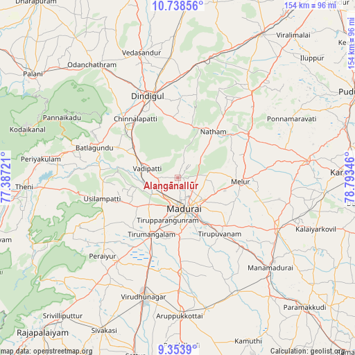
Alangānallūr GPS coordinates[2]
10° 2' 49.092" North, 78° 5' 25.188" East
| Map corner | latitude | longitude |
|---|---|---|
| Upper-left | 10.73856°, | 77.38721° |
| Center: | 10.04697°, | 78.09033° |
| Lower-right: | 9.3539°, | 78.79346° |
| Map W x H: | 154×154 km | = 95.7×95.7mi |
| max Lat: | 34.9274° ⇑96.4% North |
| Alangānallūr: | 10.04697° |
| min Lat: | ⇓3.6% South 8.09008° |
| min Long | Alangānallūr | max Long |
| 68.82655° | 78.09033° | 96.81° |
| W 49.6%⇐ | ⇒50.4% E |
Elevation
Elevation of Alangānallūr is 183 m = 600 ft, and this is 112.6 m = 369 ft below average elevation for this country.
| Max E: |
3681 m = 12077 ft | 53.1% |
| Avg. | 295.6 m = 970 ft | |
| Alangānallūr | 183 m = 600 ft | |
Min E: |
1 m = 3 ft | 46.9% |
See also: India elevation on elevation.city.
Geographical zone
Alangānallūr is located in North Torrid zone (between Equator and Tropic of Cancer). Distance of Equator is 1117.1 km =694.1 mi to South.| Distance of | km | miles | from Alangānallūr |
|---|---|---|---|
| North Pole | 8889.9 | 5523.9 | to North |
| Arctic Circle | 6284.1 | 3904.8 | to North |
| Tropic Cancer | 1488.8 | 925.1 | to North |
| Equator | 1117.1 | 694.1 | to South |


Nearby cities:
15 places around Alangānallūr: (largest is in red/bold)
• Dindigul
37.8 km =23.5 mi,  341°
341°
• Kallupatti
44.1 km =27.4 mi,  213°
213°
• Kariapatti
41.4 km =25.7 mi,  178°
178°
• Madurai
14.6 km =9.1 mi,  167°
167°
• Melur
27.3 km =17 mi,  93°
93°
• Nattam
25.2 km =15.7 mi,  37°
37°
• Nilakottai
29.4 km =18.3 mi,  296°
296°
• Pālamedu
6.9 km =4.3 mi,  21°
21°
• Tirupparangunram
18.5 km =11.5 mi,  185°
185°
• Tiruppuvanam
30.7 km =19.1 mi,  143°
143°
• Usilampatti
34.4 km =21.4 mi,  255°
255°
• V.S.K.Valasai (Dindigul-Dist.)
30.6 km =19 mi,  12°
12°
• Vadamadurai
43.8 km =27.2 mi,  1°
1°
• Vattalkundu
38.4 km =23.9 mi,  289°
289°
• Vādippatti
14.8 km =9.2 mi, 286°
Sources, notices
• [Note1] Compared only with cities in India existing in our database
• [Src1] Map data: © OpenStreetMap contributors (CC-BY-SA)
• [Src2] Other city data from geonames.org with taken over terms of usage.
• [Src3] Geographical zone / Annual Mean Temperature by Robert A. Rohde @ Wikipedia
