Naregal geodata
Naregal (Karnataka) is a populated place; located in India in Asia/Kolkata (GMT+5.5) time zone. With population of 17,403 people, there are 2246 cities with bigger population in this country. Compared to other cities in India, 79.3% of cities are located further ↑North; 75.5% of cities are located further →East and 90.3% of cities have lower elevation than Naregal. Note1


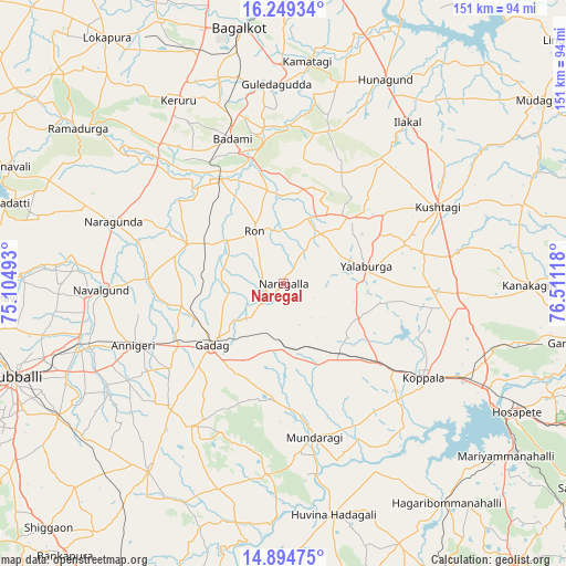
Naregal GPS coordinates[2]
15° 34' 23.376" North, 75° 48' 28.98" East
| Map corner | latitude | longitude |
|---|---|---|
| Upper-left | 16.24934°, | 75.10493° |
| Center: | 15.57316°, | 75.80805° |
| Lower-right: | 14.89475°, | 76.51118° |
| Map W x H: | 150.6×150.6 km | = 93.6×93.6mi |
| max Lat: | 34.9274° ⇑79.3% North |
| Naregal: | 15.57316° |
| min Lat: | ⇓20.7% South 8.09008° |
| min Long | Naregal | max Long |
| 68.82655° | 75.80805° | 96.81° |
| W 24.5%⇐ | ⇒75.5% E |
Elevation
Elevation of Naregal is 642 m = 2106 ft, and this is 346.4 m = 1136 ft above average elevation for this country.
| Max E: |
3681 m = 12077 ft | 9.7% |
| Naregal | 642 m 2106 ft | |
| Avg. | 295.6 m = 970 ft | |
Min E: |
1 m = 3 ft | 90.3% |
See also: India elevation on elevation.city.
Geographical zone
Naregal is located in North Torrid zone (between Equator and Tropic of Cancer). Distance of this Northern Tropic circle is 874.3 km =543.3 mi to North.| Distance of | km | miles | from Naregal |
|---|---|---|---|
| North Pole | 8275.5 | 5142.2 | to North |
| Arctic Circle | 5669.6 | 3522.9 | to North |
| Tropic Cancer | 874.3 | 543.3 | to North |
| Equator | 1731.6 | 1076 | to South |


Nearby cities:
15 places around Naregal: (largest is in red/bold)
• Annigeri
43.4 km =27 mi,  247°
247°
• Bādāmi
40.5 km =25.2 mi,  339°
339°
• Gadag
24.9 km =15.5 mi,  230°
230°
• Gadag-Betageri
26.9 km =16.7 mi, 229°
• Gajendragarh
25.1 km =15.6 mi,  43°
43°
• Kavalūr
34.8 km =21.6 mi,  155°
155°
• Koppal
45 km =28 mi,  124°
124°
• Kushtagi
45.8 km =28.5 mi,  63°
63°
• Mulgund
44.7 km =27.8 mi,  223°
223°
• Mundargi
41.5 km =25.8 mi,  168°
168°
• Nargund
48.1 km =29.9 mi,  290°
290°
• Navalgund
48.8 km =30.3 mi,  268°
268°
• Ron
16.1 km =10 mi,  330°
330°
• Shirhatti
45 km =28 mi,  212°
212°
• Yelbarga
22.3 km =13.9 mi,  77°
77°
Sources, notices
• [Note1] Compared only with cities in India existing in our database
• [Src1] Map data: © OpenStreetMap contributors (CC-BY-SA)
• [Src2] Other city data from geonames.org with taken over terms of usage.
• [Src3] Geographical zone / Annual Mean Temperature by Robert A. Rohde @ Wikipedia
