Ron geodata
Ron (Karnataka) is a populated place; located in India in Asia/Kolkata (GMT+5.5) time zone. With population of 22,593 people, there are 1867 cities with bigger population in this country. Compared to other cities in India, 78.9% of cities are located further ↑North; 76.4% of cities are located further →East and 87.2% of cities have lower elevation than Ron. Note1


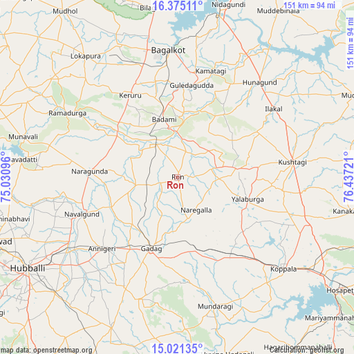
Ron GPS coordinates[2]
15° 41' 57.66" North, 75° 44' 2.688" East
| Map corner | latitude | longitude |
|---|---|---|
| Upper-left | 16.37511°, | 75.03096° |
| Center: | 15.69935°, | 75.73408° |
| Lower-right: | 15.02135°, | 76.43721° |
| Map W x H: | 150.5×150.5 km | = 93.5×93.5mi |
| max Lat: | 34.9274° ⇑78.9% North |
| Ron: | 15.69935° |
| min Lat: | ⇓21.1% South 8.09008° |
| min Long | Ron | max Long |
| 68.82655° | 75.73408° | 96.81° |
| W 23.6%⇐ | ⇒76.4% E |
Elevation
Elevation of Ron is 581 m = 1906 ft, and this is 285.4 m = 936 ft above average elevation for this country.
| Max E: |
3681 m = 12077 ft | 12.8% |
| Ron | 581 m 1906 ft | |
| Avg. | 295.6 m = 970 ft | |
Min E: |
1 m = 3 ft | 87.2% |
See also: India elevation on elevation.city.
Geographical zone
Ron is located in North Torrid zone (between Equator and Tropic of Cancer). Distance of this Northern Tropic circle is 860.3 km =534.6 mi to North.| Distance of | km | miles | from Ron |
|---|---|---|---|
| North Pole | 8261.5 | 5133.5 | to North |
| Arctic Circle | 5655.6 | 3514.2 | to North |
| Tropic Cancer | 860.3 | 534.6 | to North |
| Equator | 1745.6 | 1084.7 | to South |


Nearby cities:
15 places around Ron: (largest is in red/bold)
• Annigeri
44.3 km =27.5 mi,  226°
226°
• Bādāmi
24.7 km =15.3 mi,  345°
345°
• Gadag
32 km =19.9 mi,  200°
200°
• Gadag-Betageri
33.8 km =21 mi, 201°
• Gajendragarh
25.6 km =15.9 mi,  80°
80°
• Guledagudda
39.5 km =24.5 mi,  8°
8°
• Ilkal
49.8 km =30.9 mi,  54°
54°
• Kavalūr
50.9 km =31.6 mi,  153°
153°
• Kerūr
40.3 km =25 mi,  330°
330°
• Kushtagi
49.3 km =30.6 mi, 82°
• Mulgund
51.8 km =32.2 mi,  206°
206°
• Naregal
16.1 km =10 mi, 150°
• Nargund
37.3 km =23.2 mi,  274°
274°
• Navalgund
43.7 km =27.2 mi,  249°
249°
• Yelbarga
31.2 km =19.4 mi,  107°
107°
Sources, notices
• [Note1] Compared only with cities in India existing in our database
• [Src1] Map data: © OpenStreetMap contributors (CC-BY-SA)
• [Src2] Other city data from geonames.org with taken over terms of usage.
• [Src3] Geographical zone / Annual Mean Temperature by Robert A. Rohde @ Wikipedia
