Saundatti geodata
Saundatti (Karnataka) is a populated place; located in India in Asia/Kolkata (GMT+5.5) time zone. With population of 40,091 people, there are 1100 cities with bigger population in this country. Compared to other cities in India, 78.7% of cities are located further ↑North; 81.7% of cities are located further →East and 91.2% of cities have lower elevation than Saundatti. Note1


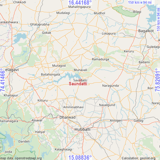
Saundatti GPS coordinates[2]
15° 45' 58.14" North, 75° 7' 4.008" East
| Map corner | latitude | longitude |
|---|---|---|
| Upper-left | 16.44168°, | 74.41466° |
| Center: | 15.76615°, | 75.11778° |
| Lower-right: | 15.08836°, | 75.82091° |
| Map W x H: | 150.5×150.5 km | = 93.5×93.5mi |
| max Lat: | 34.9274° ⇑78.7% North |
| Saundatti: | 15.76615° |
| min Lat: | ⇓21.3% South 8.09008° |
| min Long | Saundatti | max Long |
| 68.82655° | 75.11778° | 96.81° |
| W 18.3%⇐ | ⇒81.7% E |
Elevation
Elevation of Saundatti is 660 m = 2165 ft, and this is 364.4 m = 1196 ft above average elevation for this country.
| Max E: |
3681 m = 12077 ft | 8.8% |
| Saundatti | 660 m 2165 ft | |
| Avg. | 295.6 m = 970 ft | |
Min E: |
1 m = 3 ft | 91.2% |
See also: Saundatti elevation on elevation.city.
Geographical zone
Saundatti is located in North Torrid zone (between Equator and Tropic of Cancer). Distance of this Northern Tropic circle is 852.9 km =530 mi to North.| Distance of | km | miles | from Saundatti |
|---|---|---|---|
| North Pole | 8254 | 5128.8 | to North |
| Arctic Circle | 5648.1 | 3509.6 | to North |
| Tropic Cancer | 852.9 | 530 | to North |
| Equator | 1753 | 1089.3 | to South |


Nearby cities:
15 places around Saundatti: (largest is in red/bold)
• Alnāvar
55.2 km =34.3 mi,  226°
226°
• Annigeri
50.8 km =31.6 mi,  138°
138°
• Bail-Hongal
28.2 km =17.5 mi,  280°
280°
• Belgaum
66.3 km =41.2 mi, 278°
• Bādāmi
62 km =38.5 mi,  74°
74°
• Gadag-Betageri
66.1 km =41.1 mi,  126°
126°
• Gokak
54.7 km =34 mi,  324°
324°
• Haliyal
62.2 km =38.6 mi,  218°
218°
• Hubli
46.6 km =29 mi,  177°
177°
• Kerūr
53.5 km =33.2 mi,  58°
58°
• Konnūr
62.4 km =38.8 mi, 320°
• Kundgol
58.4 km =36.3 mi,  166°
166°
• Mudhol
65.5 km =40.7 mi,  15°
15°
• Nargund
29.2 km =18.1 mi,  99°
99°
• Navalgund
34.1 km =21.2 mi, 132°
Sources, notices
• [Note1] Compared only with cities in India existing in our database
• [Src1] Map data: © OpenStreetMap contributors (CC-BY-SA)
• [Src2] Other city data from geonames.org with taken over terms of usage.
• [Src3] Geographical zone / Annual Mean Temperature by Robert A. Rohde @ Wikipedia
