Bādāmi geodata
Bādāmi (Karnataka) is a populated place; located in India in Asia/Kolkata (GMT+5.5) time zone. With population of 28,314 people, there are 1521 cities with bigger population in this country. Compared to other cities in India, 78.1% of cities are located further ↑North; 76.8% of cities are located further →East and 85.9% of cities have lower elevation than Bādāmi. Note1


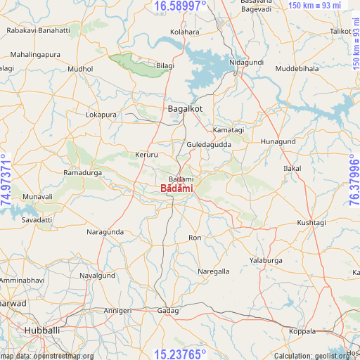
Bādāmi GPS coordinates[2]
15° 54' 53.82" North, 75° 40' 36.588" East
| Map corner | latitude | longitude |
|---|---|---|
| Upper-left | 16.58997°, | 74.97371° |
| Center: | 15.91495°, | 75.67683° |
| Lower-right: | 15.23765°, | 76.37996° |
| Map W x H: | 150.4×150.4 km | = 93.5×93.5mi |
| max Lat: | 34.9274° ⇑78.1% North |
| Bādāmi: | 15.91495° |
| min Lat: | ⇓21.9% South 8.09008° |
| min Long | Bādāmi | max Long |
| 68.82655° | 75.67683° | 96.81° |
| W 23.2%⇐ | ⇒76.8% E |
Elevation
Elevation of Bādāmi is 560 m = 1837 ft, and this is 264.4 m = 867 ft above average elevation for this country.
| Max E: |
3681 m = 12077 ft | 14.1% |
| Bādāmi | 560 m 1837 ft | |
| Avg. | 295.6 m = 970 ft | |
Min E: |
1 m = 3 ft | 85.9% |
See also: India elevation on elevation.city.
Geographical zone
Bādāmi is located in North Torrid zone (between Equator and Tropic of Cancer). Distance of this Northern Tropic circle is 836.3 km =519.7 mi to North.| Distance of | km | miles | from Bādāmi |
|---|---|---|---|
| North Pole | 8237.5 | 5118.5 | to North |
| Arctic Circle | 5631.6 | 3499.3 | to North |
| Tropic Cancer | 836.3 | 519.7 | to North |
| Equator | 1769.6 | 1099.6 | to South |


Nearby cities:
15 places around Bādāmi: (largest is in red/bold)
• Bagalkot
30.3 km =18.8 mi,  3°
3°
• Bilgi
48.5 km =30.1 mi,  352°
352°
• Gadag
54.2 km =33.7 mi,  185°
185°
• Gadag-Betageri
55.8 km =34.7 mi, 186°
• Gajendragarh
37.1 km =23.1 mi,  122°
122°
• Guledagudda
19.3 km =12 mi,  38°
38°
• Hungund
44 km =27.3 mi,  68°
68°
• Ilkal
46.9 km =29.1 mi,  83°
83°
• Kerūr
17.8 km =11.1 mi,  308°
308°
• Kushtagi
57.8 km =35.9 mi,  107°
107°
• Naregal
40.5 km =25.2 mi,  159°
159°
• Nargund
37.7 km =23.4 mi,  235°
235°
• Navalgund
52.6 km =32.7 mi,  221°
221°
• Ron
24.7 km =15.3 mi,  165°
165°
• Yelbarga
48.9 km =30.4 mi,  132°
132°
Sources, notices
• [Note1] Compared only with cities in India existing in our database
• [Src1] Map data: © OpenStreetMap contributors (CC-BY-SA)
• [Src2] Other city data from geonames.org with taken over terms of usage.
• [Src3] Geographical zone / Annual Mean Temperature by Robert A. Rohde @ Wikipedia
