Kerūr geodata
Kerūr (Karnataka) is a populated place; located in India in Asia/Kolkata (GMT+5.5) time zone. With population of 17,928 people, there are 2207 cities with bigger population in this country. Compared to other cities in India, 78% of cities are located further ↑North; 78.2% of cities are located further →East and 89.6% of cities have lower elevation than Kerūr. Note1


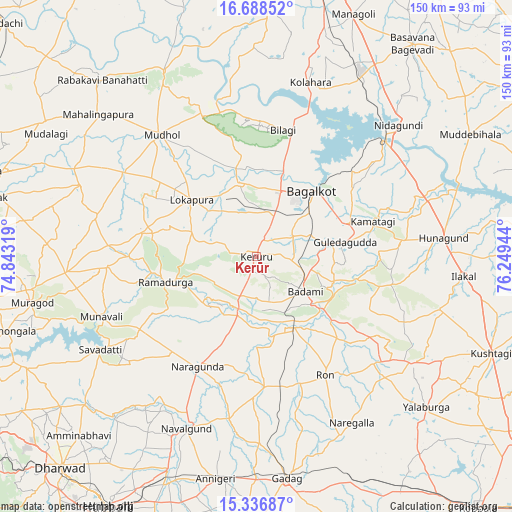
Kerūr GPS coordinates[2]
16° 0' 49.824" North, 75° 32' 46.716" East
| Map corner | latitude | longitude |
|---|---|---|
| Upper-left | 16.68852°, | 74.84319° |
| Center: | 16.01384°, | 75.54631° |
| Lower-right: | 15.33687°, | 76.24944° |
| Map W x H: | 150.3×150.3 km | = 93.4×93.4mi |
| max Lat: | 34.9274° ⇑78% North |
| Kerūr: | 16.01384° |
| min Lat: | ⇓22% South 8.09008° |
| min Long | Kerūr | max Long |
| 68.82655° | 75.54631° | 96.81° |
| W 21.8%⇐ | ⇒78.2% E |
Elevation
Elevation of Kerūr is 629 m = 2064 ft, and this is 333.4 m = 1094 ft above average elevation for this country.
| Max E: |
3681 m = 12077 ft | 10.4% |
| Kerūr | 629 m 2064 ft | |
| Avg. | 295.6 m = 970 ft | |
Min E: |
1 m = 3 ft | 89.6% |
See also: India elevation on elevation.city.
Geographical zone
Kerūr is located in North Torrid zone (between Equator and Tropic of Cancer). Distance of this Northern Tropic circle is 825.3 km =512.8 mi to North.| Distance of | km | miles | from Kerūr |
|---|---|---|---|
| North Pole | 8226.5 | 5111.7 | to North |
| Arctic Circle | 5620.6 | 3492.5 | to North |
| Tropic Cancer | 825.3 | 512.8 | to North |
| Equator | 1780.6 | 1106.4 | to South |


Nearby cities:
15 places around Kerūr: (largest is in red/bold)
• Bagalkot
25 km =15.5 mi,  39°
39°
• Bilgi
37.8 km =23.5 mi,  11°
11°
• Bādāmi
17.8 km =11.1 mi,  128°
128°
• Gajendragarh
54.8 km =34.1 mi,  124°
124°
• Guledagudda
26.4 km =16.4 mi,  81°
81°
• Hungund
55 km =34.2 mi, 84°
• Ilkal
60.9 km =37.8 mi,  95°
95°
• Jamkhandi
61 km =37.9 mi,  333°
333°
• Mahālingpur
62.6 km =38.9 mi,  311°
311°
• Mudhol
45.3 km =28.1 mi,  321°
321°
• Naregal
56.4 km =35 mi,  150°
150°
• Nargund
36.6 km =22.7 mi,  207°
207°
• Navalgund
54.7 km =34 mi,  202°
202°
• Ron
40.3 km =25 mi, 150°
• Saundatti
53.5 km =33.2 mi,  238°
238°
Sources, notices
• [Note1] Compared only with cities in India existing in our database
• [Src1] Map data: © OpenStreetMap contributors (CC-BY-SA)
• [Src2] Other city data from geonames.org with taken over terms of usage.
• [Src3] Geographical zone / Annual Mean Temperature by Robert A. Rohde @ Wikipedia
