Ludhiāna geodata
Ludhiāna (Punjab) is a populated place; located in India in Asia/Kolkata (GMT+5.5) time zone. With population of 1,545,368 people, there are 17 cities with bigger population in this country. Compared to other cities in India, 95.5% of cities are located further ↓South; 75.2% of cities are located further →East and 60.7% of cities have lower elevation than Ludhiāna. Note1


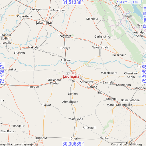
Ludhiāna GPS coordinates[2]
30° 54' 43.344" North, 75° 51' 13.644" East
| Map corner | latitude | longitude |
|---|---|---|
| Upper-left | 31.51338°, | 75.15067° |
| Center: | 30.91204°, | 75.85379° |
| Lower-right: | 30.30689°, | 76.55692° |
| Map W x H: | 134.1×134.1 km | = 83.3×83.3mi |
| max Lat: | 34.9274° ⇑4.5% North |
| Ludhiāna: | 30.91204° |
| min Lat: | ⇓95.5% South 8.09008° |
| min Long | Ludhiāna | max Long |
| 68.82655° | 75.85379° | 96.81° |
| W 24.8%⇐ | ⇒75.2% E |
Elevation
Elevation of Ludhiāna is 256 m = 840 ft, and this is 39.6 m = 130 ft below average elevation for this country.
| Max E: |
3681 m = 12077 ft | 39.3% |
| Avg. | 295.6 m = 970 ft | |
| Ludhiāna | 256 m = 840 ft | |
Min E: |
1 m = 3 ft | 60.7% |
See also: Ludhiāna elevation on elevation.city.
Geographical zone
Ludhiāna is located in North temperate zone (between Tropic of Cancer and the Arctic Circle). Distance of this Northern Tropic circle is 831.2 km =516.5 mi to South.| Distance of | km | miles | from Ludhiāna |
|---|---|---|---|
| North Pole | 6570 | 4082.4 | to North |
| Arctic Circle | 3964.1 | 2463.2 | to North |
| Tropic Cancer | 831.2 | 516.5 | to South |
| Equator | 3437.1 | 2135.7 | to South |


Nearby cities:
15 places around Ludhiāna: (largest is in red/bold)
• Banga
33.6 km =20.9 mi,  23°
23°
• Chīma
33.6 km =20.9 mi,  138°
138°
• Dorāha
20.5 km =12.7 mi,  127°
127°
• Jagraon
38.8 km =24.1 mi,  249°
249°
• Jandiāla
35.5 km =22.1 mi,  320°
320°
• Khanna
42 km =26.1 mi,  123°
123°
• Māchhīwāra
33 km =20.5 mi,  89°
89°
• Māler Kotla
42.4 km =26.3 mi,  176°
176°
• Nawanshahr
34.4 km =21.4 mi,  46°
46°
• Nūrmahal
32.2 km =20 mi,  309°
309°
• Phagwāra
35.6 km =22.1 mi,  347°
347°
• Phillaur
13.3 km =8.3 mi,  333°
333°
• Rāhon
29.7 km =18.5 mi,  58°
58°
• Rāikot
37.9 km =23.5 mi,  219°
219°
• Samrāla
33.5 km =20.8 mi,  104°
104°
Sources, notices
• [Note1] Compared only with cities in India existing in our database
• [Src1] Map data: © OpenStreetMap contributors (CC-BY-SA)
• [Src2] Other city data from geonames.org with taken over terms of usage.
• [Src3] Geographical zone / Annual Mean Temperature by Robert A. Rohde @ Wikipedia
