Murtajāpur geodata
Murtajāpur (Maharashtra) is a populated place; located in India in Asia/Kolkata (GMT+5.5) time zone. With population of 40,223 people, there are 1093 cities with bigger population in this country. Compared to other cities in India, 62.8% of cities are located further ↑North; 58.7% of cities are located further →East and 67.2% of cities have lower elevation than Murtajāpur. Note1


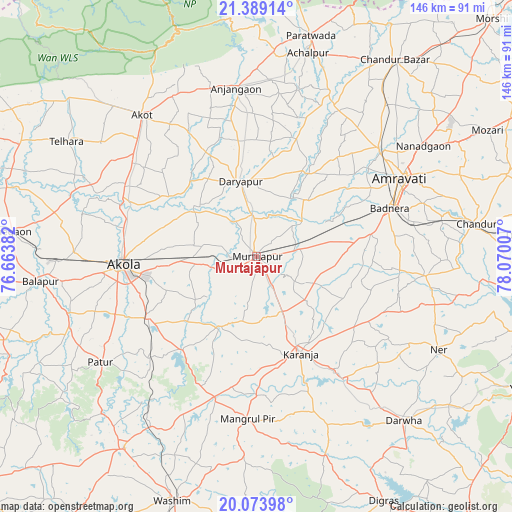
Murtajāpur GPS coordinates[2]
20° 43' 58.764" North, 77° 22' 0.984" East
| Map corner | latitude | longitude |
|---|---|---|
| Upper-left | 21.38914°, | 76.66382° |
| Center: | 20.73299°, | 77.36694° |
| Lower-right: | 20.07398°, | 78.07007° |
| Map W x H: | 146.2×146.2 km | = 90.8×90.8mi |
| max Lat: | 34.9274° ⇑62.8% North |
| Murtajāpur: | 20.73299° |
| min Lat: | ⇓37.2% South 8.09008° |
| min Long | Murtajāpur | max Long |
| 68.82655° | 77.36694° | 96.81° |
| W 41.3%⇐ | ⇒58.7% E |
Elevation
Elevation of Murtajāpur is 303 m = 994 ft, and this is 7.4 m = 24 ft above average elevation for this country.
| Max E: |
3681 m = 12077 ft | 32.8% |
| Murtajāpur | 303 m 994 ft | |
| Avg. | 295.6 m = 970 ft | |
Min E: |
1 m = 3 ft | 67.2% |
See also: Murtajāpur elevation on elevation.city.
Geographical zone
Murtajāpur is located in North Torrid zone (between Equator and Tropic of Cancer). Distance of this Northern Tropic circle is 300.6 km =186.8 mi to North.| Distance of | km | miles | from Murtajāpur |
|---|---|---|---|
| North Pole | 7701.8 | 4785.7 | to North |
| Arctic Circle | 5095.9 | 3166.4 | to North |
| Tropic Cancer | 300.6 | 186.8 | to North |
| Equator | 2305.3 | 1432.4 | to South |


Nearby cities:
15 places around Murtajāpur: (largest is in red/bold)
• Achalpur
60.1 km =37.3 mi,  14°
14°
• Akola
38.4 km =23.9 mi,  266°
266°
• Akot
51.5 km =32 mi,  321°
321°
• Amrāvati
45.6 km =28.3 mi,  60°
60°
• Anjangaon
48.4 km =30.1 mi,  352°
352°
• Bālāpur
62.1 km =38.6 mi,  263°
263°
• Chāndūr
64.4 km =40 mi,  81°
81°
• Chāndūr Bāzār
68.7 km =42.7 mi,  35°
35°
• Daryāpur
21.7 km =13.5 mi, 348°
• Dārwha
63.2 km =39.3 mi,  138°
138°
• Kāranja
30.6 km =19 mi,  155°
155°
• Mangrūl Pīr
46.7 km =29 mi,  183°
183°
• Pātūr
54 km =33.6 mi,  235°
235°
• Shegaon
69.7 km =43.3 mi,  275°
275°
• Telhāra
63.9 km =39.7 mi,  300°
300°
Sources, notices
• [Note1] Compared only with cities in India existing in our database
• [Src1] Map data: © OpenStreetMap contributors (CC-BY-SA)
• [Src2] Other city data from geonames.org with taken over terms of usage.
• [Src3] Geographical zone / Annual Mean Temperature by Robert A. Rohde @ Wikipedia
