Akot geodata
Akot (Maharashtra) is a populated place; located in India in Asia/Kolkata (GMT+5.5) time zone. With population of 86,917 people, there are 514 cities with bigger population in this country. Compared to other cities in India, 61.3% of cities are located further ↑North; 62.5% of cities are located further →East and 68.4% of cities have lower elevation than Akot. Note1


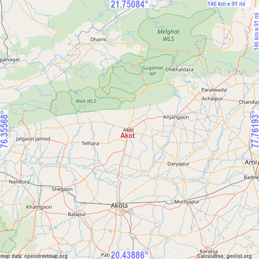
Akot GPS coordinates[2]
21° 5' 46.68" North, 77° 3' 31.68" East
| Map corner | latitude | longitude |
|---|---|---|
| Upper-left | 21.75084°, | 76.35568° |
| Center: | 21.0963°, | 77.0588° |
| Lower-right: | 20.43886°, | 77.76193° |
| Map W x H: | 145.9×145.9 km | = 90.7×90.7mi |
| max Lat: | 34.9274° ⇑61.3% North |
| Akot: | 21.0963° |
| min Lat: | ⇓38.7% South 8.09008° |
| min Long | Akot | max Long |
| 68.82655° | 77.0588° | 96.81° |
| W 37.5%⇐ | ⇒62.5% E |
Elevation
Elevation of Akot is 311 m = 1020 ft, and this is 15.4 m = 51 ft above average elevation for this country.
| Max E: |
3681 m = 12077 ft | 31.6% |
| Akot | 311 m 1020 ft | |
| Avg. | 295.6 m = 970 ft | |
Min E: |
1 m = 3 ft | 68.4% |
See also: Akot elevation on elevation.city.
Geographical zone
Akot is located in North Torrid zone (between Equator and Tropic of Cancer). Distance of this Northern Tropic circle is 260.2 km =161.7 mi to North.| Distance of | km | miles | from Akot |
|---|---|---|---|
| North Pole | 7661.4 | 4760.6 | to North |
| Arctic Circle | 5055.5 | 3141.3 | to North |
| Tropic Cancer | 260.2 | 161.7 | to North |
| Equator | 2345.7 | 1457.5 | to South |


Nearby cities:
15 places around Akot: (largest is in red/bold)
• Achalpur
50.1 km =31.1 mi,  69°
69°
• Akola
43.5 km =27 mi,  188°
188°
• Amrāvati
74 km =46 mi,  104°
104°
• Anjangaon
27.1 km =16.8 mi, 73°
• Bālāpur
56.3 km =35 mi,  211°
211°
• Chāndūr Bāzār
73.1 km =45.4 mi,  77°
77°
• Daryāpur
33.7 km =20.9 mi,  124°
124°
• Jalgaon Jamod
54.6 km =33.9 mi,  264°
264°
• Khāmgaon
66.8 km =41.5 mi,  229°
229°
• Murtajāpur
51.5 km =32 mi,  141°
141°
• Nepānagar
79.6 km =49.5 mi,  299°
299°
• Nāndūra Buzurg
68.7 km =42.7 mi,  244°
244°
• Pātūr
71.8 km =44.6 mi, 190°
• Shegaon
50.3 km =31.3 mi, 227°
• Telhāra
24.1 km =15 mi,  251°
251°
Sources, notices
• [Note1] Compared only with cities in India existing in our database
• [Src1] Map data: © OpenStreetMap contributors (CC-BY-SA)
• [Src2] Other city data from geonames.org with taken over terms of usage.
• [Src3] Geographical zone / Annual Mean Temperature by Robert A. Rohde @ Wikipedia
