Dārwha geodata
Dārwha (Maharashtra) is a populated place; located in India in Asia/Kolkata (GMT+5.5) time zone. With population of 23,062 people, there are 1834 cities with bigger population in this country. Compared to other cities in India, 64.2% of cities are located further ↑North; 54.1% of cities are located further →East and 71.1% of cities have lower elevation than Dārwha. Note1


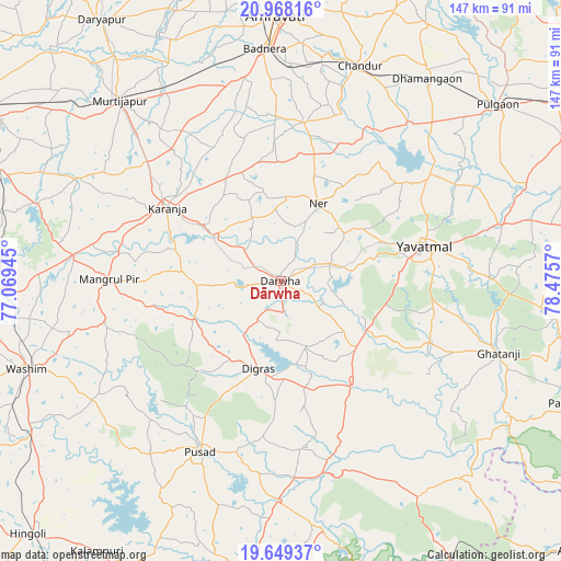
Dārwha GPS coordinates[2]
20° 18' 36.612" North, 77° 46' 21.252" East
| Map corner | latitude | longitude |
|---|---|---|
| Upper-left | 20.96816°, | 77.06945° |
| Center: | 20.31017°, | 77.77257° |
| Lower-right: | 19.64937°, | 78.4757° |
| Map W x H: | 146.6×146.6 km | = 91.1×91.1mi |
| max Lat: | 34.9274° ⇑64.2% North |
| Dārwha: | 20.31017° |
| min Lat: | ⇓35.8% South 8.09008° |
| min Long | Dārwha | max Long |
| 68.82655° | 77.77257° | 96.81° |
| W 45.9%⇐ | ⇒54.1% E |
Elevation
Elevation of Dārwha is 337 m = 1106 ft, and this is 41.4 m = 136 ft above average elevation for this country.
| Max E: |
3681 m = 12077 ft | 28.9% |
| Dārwha | 337 m 1106 ft | |
| Avg. | 295.6 m = 970 ft | |
Min E: |
1 m = 3 ft | 71.1% |
See also: India elevation on elevation.city.
Geographical zone
Dārwha is located in North Torrid zone (between Equator and Tropic of Cancer). Distance of this Northern Tropic circle is 347.6 km =216 mi to North.| Distance of | km | miles | from Dārwha |
|---|---|---|---|
| North Pole | 7748.8 | 4814.9 | to North |
| Arctic Circle | 5142.9 | 3195.6 | to North |
| Tropic Cancer | 347.6 | 216 | to North |
| Equator | 2258.3 | 1403.2 | to South |


Nearby cities:
15 places around Dārwha: (largest is in red/bold)
• Amrāvati
69.3 km =43.1 mi,  358°
358°
• Anshing
56.4 km =35 mi,  237°
237°
• Chāndūr
60.1 km =37.3 mi,  21°
21°
• Daryāpur
82.6 km =51.3 mi,  325°
325°
• Dattāpur
64.9 km =40.3 mi,  36°
36°
• Digras
23.7 km =14.7 mi,  193°
193°
• Ghātanji
59.4 km =36.9 mi,  108°
108°
• Kāranja
35.3 km =21.9 mi,  302°
302°
• Mangrūl Pīr
44.9 km =27.9 mi,  270°
270°
• Murtajāpur
63.2 km =39.3 mi,  318°
318°
• Pulgaon
73.2 km =45.5 mi,  51°
51°
• Pusad
48.6 km =30.2 mi,  204°
204°
• Umarkhed
79.3 km =49.3 mi, 186°
• Wāshīm
70.3 km =43.7 mi,  251°
251°
• Yavatmāl
38.6 km =24 mi,  76°
76°
Sources, notices
• [Note1] Compared only with cities in India existing in our database
• [Src1] Map data: © OpenStreetMap contributors (CC-BY-SA)
• [Src2] Other city data from geonames.org with taken over terms of usage.
• [Src3] Geographical zone / Annual Mean Temperature by Robert A. Rohde @ Wikipedia
