Chāndūr geodata
Chāndūr (Maharashtra) is a populated place; located in India in Asia/Kolkata (GMT+5.5) time zone. With population of 19,163 people, there are 2113 cities with bigger population in this country. Compared to other cities in India, 62.4% of cities are located further ↑North; 51.5% of cities are located further →East and 70.3% of cities have lower elevation than Chāndūr. Note1


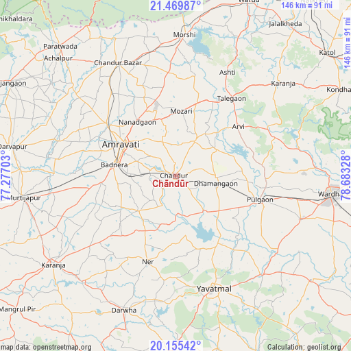
Chāndūr GPS coordinates[2]
20° 48' 50.688" North, 77° 58' 48.54" East
| Map corner | latitude | longitude |
|---|---|---|
| Upper-left | 21.46987°, | 77.27703° |
| Center: | 20.81408°, | 77.98015° |
| Lower-right: | 20.15542°, | 78.68328° |
| Map W x H: | 146.2×146.2 km | = 90.8×90.8mi |
| max Lat: | 34.9274° ⇑62.4% North |
| Chāndūr: | 20.81408° |
| min Lat: | ⇓37.6% South 8.09008° |
| min Long | Chāndūr | max Long |
| 68.82655° | 77.98015° | 96.81° |
| W 48.5%⇐ | ⇒51.5% E |
Elevation
Elevation of Chāndūr is 330 m = 1083 ft, and this is 34.4 m = 113 ft above average elevation for this country.
| Max E: |
3681 m = 12077 ft | 29.7% |
| Chāndūr | 330 m 1083 ft | |
| Avg. | 295.6 m = 970 ft | |
Min E: |
1 m = 3 ft | 70.3% |
See also: India elevation on elevation.city.
Geographical zone
Chāndūr is located in North Torrid zone (between Equator and Tropic of Cancer). Distance of this Northern Tropic circle is 291.6 km =181.2 mi to North.| Distance of | km | miles | from Chāndūr |
|---|---|---|---|
| North Pole | 7692.8 | 4780.1 | to North |
| Arctic Circle | 5086.9 | 3160.9 | to North |
| Tropic Cancer | 291.6 | 181.2 | to North |
| Equator | 2314.3 | 1438 | to South |


Nearby cities:
15 places around Chāndūr: (largest is in red/bold)
• Achalpur
69.3 km =43.1 mi,  315°
315°
• Amrāvati
27.3 km =17 mi,  299°
299°
• Chāndūr Bāzār
53 km =32.9 mi,  332°
332°
• Daryāpur
69 km =42.9 mi,  280°
280°
• Dattāpur
17.1 km =10.6 mi,  102°
102°
• Deoli
55.1 km =34.2 mi,  109°
109°
• Dārwha
60.1 km =37.3 mi,  201°
201°
• Kāranja
63 km =39.1 mi,  234°
234°
• Morsi
58.6 km =36.4 mi,  3°
3°
• Murtajāpur
64.4 km =40 mi,  261°
261°
• Pulgaon
36.8 km =22.9 mi, 106°
• Sonegaon
76.8 km =47.7 mi, 105°
• Wardha
64.7 km =40.2 mi, 97°
• Yavatmāl
49.4 km =30.7 mi,  161°
161°
• Ārvi
32.8 km =20.4 mi,  51°
51°
Sources, notices
• [Note1] Compared only with cities in India existing in our database
• [Src1] Map data: © OpenStreetMap contributors (CC-BY-SA)
• [Src2] Other city data from geonames.org with taken over terms of usage.
• [Src3] Geographical zone / Annual Mean Temperature by Robert A. Rohde @ Wikipedia
