Shegaon geodata
Shegaon (Maharashtra) is a populated place; located in India in Asia/Kolkata (GMT+5.5) time zone. With population of 56,449 people, there are 786 cities with bigger population in this country. Compared to other cities in India, 62.5% of cities are located further ↑North; 66.3% of cities are located further →East and 63.4% of cities have lower elevation than Shegaon. Note1


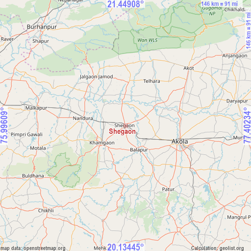
Shegaon GPS coordinates[2]
20° 47' 35.52" North, 76° 41' 57.156" East
| Map corner | latitude | longitude |
|---|---|---|
| Upper-left | 21.44908°, | 75.99609° |
| Center: | 20.7932°, | 76.69921° |
| Lower-right: | 20.13445°, | 77.40234° |
| Map W x H: | 146.2×146.2 km | = 90.8×90.8mi |
| max Lat: | 34.9274° ⇑62.5% North |
| Shegaon: | 20.7932° |
| min Lat: | ⇓37.5% South 8.09008° |
| min Long | Shegaon | max Long |
| 68.82655° | 76.69921° | 96.81° |
| W 33.7%⇐ | ⇒66.3% E |
Elevation
Elevation of Shegaon is 275 m = 902 ft, and this is 20.6 m = 68 ft below average elevation for this country.
| Max E: |
3681 m = 12077 ft | 36.6% |
| Avg. | 295.6 m = 970 ft | |
| Shegaon | 275 m = 902 ft | |
Min E: |
1 m = 3 ft | 63.4% |
See also: Shegaon elevation on elevation.city.
Geographical zone
Shegaon is located in North Torrid zone (between Equator and Tropic of Cancer). Distance of this Northern Tropic circle is 293.9 km =182.6 mi to North.| Distance of | km | miles | from Shegaon |
|---|---|---|---|
| North Pole | 7695.1 | 4781.5 | to North |
| Arctic Circle | 5089.2 | 3162.3 | to North |
| Tropic Cancer | 293.9 | 182.6 | to North |
| Equator | 2312 | 1436.6 | to South |


Nearby cities:
15 places around Shegaon: (largest is in red/bold)
• Akola
32.4 km =20.1 mi,  106°
106°
• Akot
50.3 km =31.3 mi,  47°
47°
• Buldāna
61.1 km =38 mi,  241°
241°
• Bālāpur
16.1 km =10 mi,  151°
151°
• Chikhli
67.3 km =41.8 mi,  223°
223°
• Daryāpur
66.8 km =41.5 mi,  77°
77°
• Jalgaon Jamod
33.5 km =20.8 mi,  329°
329°
• Khāmgaon
16.6 km =10.3 mi,  234°
234°
• Malkāpur
53 km =32.9 mi,  281°
281°
• Mehekar
72.7 km =45.2 mi,  190°
190°
• Murtajāpur
69.7 km =43.3 mi,  95°
95°
• Nāndūra Buzurg
25.4 km =15.8 mi, 280°
• Pātūr
44.5 km =27.7 mi, 146°
• Shāhpur
69.7 km =43.3 mi,  315°
315°
• Telhāra
29.8 km =18.5 mi,  29°
29°
Sources, notices
• [Note1] Compared only with cities in India existing in our database
• [Src1] Map data: © OpenStreetMap contributors (CC-BY-SA)
• [Src2] Other city data from geonames.org with taken over terms of usage.
• [Src3] Geographical zone / Annual Mean Temperature by Robert A. Rohde @ Wikipedia
