Akola geodata
Akola (Maharashtra) is a populated place; located in India in Asia/Kolkata (GMT+5.5) time zone. With population of 428,857 people, there are 105 cities with bigger population in this country. Compared to other cities in India, 63% of cities are located further ↑North; 63.2% of cities are located further →East and 64.9% of cities have lower elevation than Akola. Note1


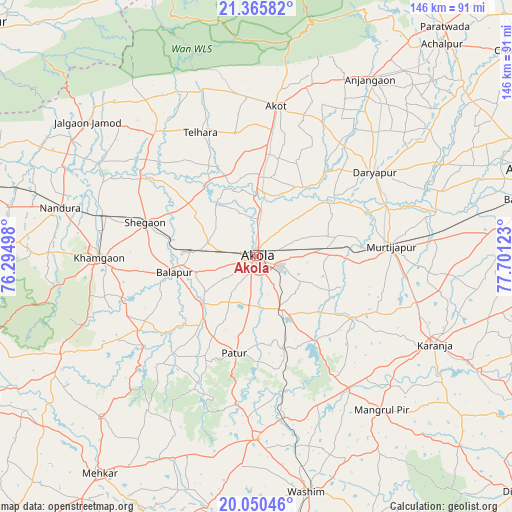
Akola GPS coordinates[2]
20° 42' 34.452" North, 76° 59' 53.16" East
| Map corner | latitude | longitude |
|---|---|---|
| Upper-left | 21.36582°, | 76.29498° |
| Center: | 20.70957°, | 76.9981° |
| Lower-right: | 20.05046°, | 77.70123° |
| Map W x H: | 146.3×146.3 km | = 90.9×90.9mi |
| max Lat: | 34.9274° ⇑63% North |
| Akola: | 20.70957° |
| min Lat: | ⇓37% South 8.09008° |
| min Long | Akola | max Long |
| 68.82655° | 76.9981° | 96.81° |
| W 36.8%⇐ | ⇒63.2% E |
Elevation
Elevation of Akola is 285 m = 935 ft, and this is 10.6 m = 35 ft below average elevation for this country.
| Max E: |
3681 m = 12077 ft | 35.1% |
| Avg. | 295.6 m = 970 ft | |
| Akola | 285 m = 935 ft | |
Min E: |
1 m = 3 ft | 64.9% |
See also: Akola elevation on elevation.city.
Geographical zone
Akola is located in North Torrid zone (between Equator and Tropic of Cancer). Distance of this Northern Tropic circle is 303.2 km =188.4 mi to North.| Distance of | km | miles | from Akola |
|---|---|---|---|
| North Pole | 7704.4 | 4787.3 | to North |
| Arctic Circle | 5098.5 | 3168.1 | to North |
| Tropic Cancer | 303.2 | 188.4 | to North |
| Equator | 2302.7 | 1430.8 | to South |


Nearby cities:
15 places around Akola: (largest is in red/bold)
• Akot
43.5 km =27 mi,  8°
8°
• Anjangaon
60.1 km =37.3 mi,  32°
32°
• Bālāpur
23.8 km =14.8 mi,  258°
258°
• Daryāpur
41.7 km =25.9 mi,  54°
54°
• Jalgaon Jamod
61.4 km =38.2 mi,  308°
308°
• Khāmgaon
44.7 km =27.8 mi,  269°
269°
• Kāranja
56.9 km =35.4 mi,  116°
116°
• Mangrūl Pīr
56.7 km =35.2 mi,  140°
140°
• Mehekar
76.6 km =47.6 mi,  215°
215°
• Murtajāpur
38.4 km =23.9 mi,  86°
86°
• Nāndūra Buzurg
57.7 km =35.9 mi,  283°
283°
• Pātūr
28.4 km =17.6 mi,  192°
192°
• Shegaon
32.4 km =20.1 mi,  286°
286°
• Telhāra
39 km =24.2 mi,  334°
334°
• Wāshīm
68 km =42.3 mi,  168°
168°
Sources, notices
• [Note1] Compared only with cities in India existing in our database
• [Src1] Map data: © OpenStreetMap contributors (CC-BY-SA)
• [Src2] Other city data from geonames.org with taken over terms of usage.
• [Src3] Geographical zone / Annual Mean Temperature by Robert A. Rohde @ Wikipedia
