Bālāpur geodata
Bālāpur (Maharashtra) is a populated place; located in India in Asia/Kolkata (GMT+5.5) time zone. With population of 42,401 people, there are 1042 cities with bigger population in this country. Compared to other cities in India, 63.2% of cities are located further ↑North; 65.4% of cities are located further →East and 63.8% of cities have lower elevation than Bālāpur. Note1


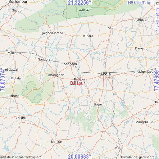
Bālāpur GPS coordinates[2]
20° 39' 58.032" North, 76° 46' 25.896" East
| Map corner | latitude | longitude |
|---|---|---|
| Upper-left | 21.32256°, | 76.07074° |
| Center: | 20.66612°, | 76.77386° |
| Lower-right: | 20.00683°, | 77.47699° |
| Map W x H: | 146.3×146.3 km | = 90.9×90.9mi |
| max Lat: | 34.9274° ⇑63.2% North |
| Bālāpur: | 20.66612° |
| min Lat: | ⇓36.8% South 8.09008° |
| min Long | Bālāpur | max Long |
| 68.82655° | 76.77386° | 96.81° |
| W 34.6%⇐ | ⇒65.4% E |
Elevation
Elevation of Bālāpur is 277 m = 909 ft, and this is 18.6 m = 61 ft below average elevation for this country.
| Max E: |
3681 m = 12077 ft | 36.2% |
| Avg. | 295.6 m = 970 ft | |
| Bālāpur | 277 m = 909 ft | |
Min E: |
1 m = 3 ft | 63.8% |
See also: Bālāpur elevation on elevation.city.
Geographical zone
Bālāpur is located in North Torrid zone (between Equator and Tropic of Cancer). Distance of this Northern Tropic circle is 308.1 km =191.4 mi to North.| Distance of | km | miles | from Bālāpur |
|---|---|---|---|
| North Pole | 7709.2 | 4790.3 | to North |
| Arctic Circle | 5103.3 | 3171 | to North |
| Tropic Cancer | 308.1 | 191.4 | to North |
| Equator | 2297.9 | 1427.8 | to South |


Nearby cities:
15 places around Bālāpur: (largest is in red/bold)
• Akola
23.8 km =14.8 mi,  78°
78°
• Akot
56.3 km =35 mi,  31°
31°
• Buldāna
63.2 km =39.3 mi,  256°
256°
• Chikhli
64.2 km =39.9 mi,  236°
236°
• Daryāpur
64.2 km =39.9 mi,  63°
63°
• Jalgaon Jamod
49.6 km =30.8 mi,  329°
329°
• Khāmgaon
21.9 km =13.6 mi,  282°
282°
• Malkāpur
64.5 km =40.1 mi,  292°
292°
• Mangrūl Pīr
70.9 km =44.1 mi,  123°
123°
• Mehekar
61.2 km =38 mi,  200°
200°
• Murtajāpur
62.1 km =38.6 mi, 83°
• Nāndūra Buzurg
37.7 km =23.4 mi,  299°
299°
• Pātūr
28.5 km =17.7 mi,  143°
143°
• Shegaon
16.1 km =10 mi, 331°
• Telhāra
40.7 km =25.3 mi,  9°
9°
Sources, notices
• [Note1] Compared only with cities in India existing in our database
• [Src1] Map data: © OpenStreetMap contributors (CC-BY-SA)
• [Src2] Other city data from geonames.org with taken over terms of usage.
• [Src3] Geographical zone / Annual Mean Temperature by Robert A. Rohde @ Wikipedia
