Mundargi geodata
Mundargi (Karnataka) is a populated place; located in India in Asia/Kolkata (GMT+5.5) time zone. With population of 21,826 people, there are 1913 cities with bigger population in this country. Compared to other cities in India, 81.3% of cities are located further ↑North; 74.9% of cities are located further →East and 84.1% of cities have lower elevation than Mundargi. Note1


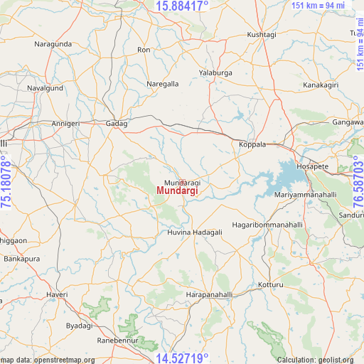
Mundargi GPS coordinates[2]
15° 12' 24.372" North, 75° 53' 2.04" East
| Map corner | latitude | longitude |
|---|---|---|
| Upper-left | 15.88417°, | 75.18078° |
| Center: | 15.20677°, | 75.8839° |
| Lower-right: | 14.52719°, | 76.58703° |
| Map W x H: | 150.9×150.9 km | = 93.8×93.8mi |
| max Lat: | 34.9274° ⇑81.3% North |
| Mundargi: | 15.20677° |
| min Lat: | ⇓18.7% South 8.09008° |
| min Long | Mundargi | max Long |
| 68.82655° | 75.8839° | 96.81° |
| W 25.1%⇐ | ⇒74.9% E |
Elevation
Elevation of Mundargi is 534 m = 1752 ft, and this is 238.4 m = 782 ft above average elevation for this country.
| Max E: |
3681 m = 12077 ft | 15.9% |
| Mundargi | 534 m 1752 ft | |
| Avg. | 295.6 m = 970 ft | |
Min E: |
1 m = 3 ft | 84.1% |
See also: India elevation on elevation.city.
Geographical zone
Mundargi is located in North Torrid zone (between Equator and Tropic of Cancer). Distance of this Northern Tropic circle is 915.1 km =568.6 mi to North.| Distance of | km | miles | from Mundargi |
|---|---|---|---|
| North Pole | 8316.2 | 5167.4 | to North |
| Arctic Circle | 5710.3 | 3548.2 | to North |
| Tropic Cancer | 915.1 | 568.6 | to North |
| Equator | 1690.8 | 1050.6 | to South |


Nearby cities:
15 places around Mundargi: (largest is in red/bold)
• Annigeri
54.1 km =33.6 mi,  296°
296°
• Gadag
36.8 km =22.9 mi,  312°
312°
• Gadag-Betageri
37 km =23 mi, 309°
• Hadagalli
21.3 km =13.2 mi,  166°
166°
• Harpanahalli
47.9 km =29.8 mi, 166°
• Hospet
54.4 km =33.8 mi,  82°
82°
• Kavalūr
11.1 km =6.9 mi,  35°
35°
• Koppal
32.9 km =20.4 mi,  62°
62°
• Kottūru
55.8 km =34.7 mi,  139°
139°
• Lakshmeshwar
45.4 km =28.2 mi,  258°
258°
• Mulgund
39.8 km =24.7 mi,  281°
281°
• Munirābād
50.1 km =31.1 mi, 76°
• Naregal
41.5 km =25.8 mi,  348°
348°
• Shirhatti
32.7 km =20.3 mi, 275°
• Yelbarga
47.5 km =29.5 mi,  16°
16°
Sources, notices
• [Note1] Compared only with cities in India existing in our database
• [Src1] Map data: © OpenStreetMap contributors (CC-BY-SA)
• [Src2] Other city data from geonames.org with taken over terms of usage.
• [Src3] Geographical zone / Annual Mean Temperature by Robert A. Rohde @ Wikipedia
