Koppal geodata
Koppal (Karnataka) is a populated place; located in India in Asia/Kolkata (GMT+5.5) time zone. With population of 60,868 people, there are 718 cities with bigger population in this country. Compared to other cities in India, 80.6% of cities are located further ↑North; 72.1% of cities are located further →East and 84.4% of cities have lower elevation than Koppal. Note1


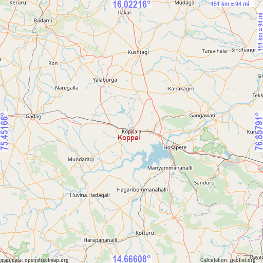
Koppal GPS coordinates[2]
15° 20' 42.792" North, 76° 9' 17.208" East
| Map corner | latitude | longitude |
|---|---|---|
| Upper-left | 16.02216°, | 75.45166° |
| Center: | 15.34522°, | 76.15478° |
| Lower-right: | 14.66608°, | 76.85791° |
| Map W x H: | 150.8×150.8 km | = 93.7×93.7mi |
| max Lat: | 34.9274° ⇑80.6% North |
| Koppal: | 15.34522° |
| min Lat: | ⇓19.4% South 8.09008° |
| min Long | Koppal | max Long |
| 68.82655° | 76.15478° | 96.81° |
| W 27.9%⇐ | ⇒72.1% E |
Elevation
Elevation of Koppal is 540 m = 1772 ft, and this is 244.4 m = 802 ft above average elevation for this country.
| Max E: |
3681 m = 12077 ft | 15.6% |
| Koppal | 540 m 1772 ft | |
| Avg. | 295.6 m = 970 ft | |
Min E: |
1 m = 3 ft | 84.4% |
See also: Koppal elevation on elevation.city.
Geographical zone
Koppal is located in North Torrid zone (between Equator and Tropic of Cancer). Distance of this Northern Tropic circle is 899.7 km =559 mi to North.| Distance of | km | miles | from Koppal |
|---|---|---|---|
| North Pole | 8300.8 | 5157.9 | to North |
| Arctic Circle | 5694.9 | 3538.6 | to North |
| Tropic Cancer | 899.7 | 559 | to North |
| Equator | 1706.2 | 1060.2 | to South |


Nearby cities:
15 places around Koppal: (largest is in red/bold)
• Gadag
57.1 km =35.5 mi,  279°
279°
• Gajendragarh
47.8 km =29.7 mi,  335°
335°
• Gangāwati
41.3 km =25.7 mi,  76°
76°
• Hadagalli
43.3 km =26.9 mi,  213°
213°
• Hampi
32.8 km =20.4 mi,  91°
91°
• Hospet
26.3 km =16.3 mi,  108°
108°
• Kampli
48.2 km =30 mi, 81°
• Kavalūr
23.5 km =14.6 mi,  254°
254°
• Kushtagi
45.9 km =28.5 mi,  4°
4°
• Kūdligi
54.8 km =34.1 mi,  153°
153°
• Mundargi
32.9 km =20.4 mi,  242°
242°
• Munirābād
20.1 km =12.5 mi,  101°
101°
• Naregal
45 km =28 mi,  304°
304°
• Sandūr
51 km =31.7 mi,  124°
124°
• Yelbarga
33.7 km =20.9 mi,  332°
332°
Sources, notices
• [Note1] Compared only with cities in India existing in our database
• [Src1] Map data: © OpenStreetMap contributors (CC-BY-SA)
• [Src2] Other city data from geonames.org with taken over terms of usage.
• [Src3] Geographical zone / Annual Mean Temperature by Robert A. Rohde @ Wikipedia
