Kavalūr geodata
Kavalūr (Karnataka) is a populated place; located in India in Asia/Kolkata (GMT+5.5) time zone. With population of 1,010 people, there are 3462 cities with bigger population in this country. Compared to other cities in India, 80.7% of cities are located further ↑North; 74.2% of cities are located further →East and 84.8% of cities have lower elevation than Kavalūr. Note1


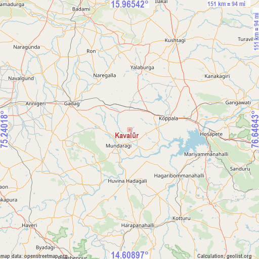
Kavalūr GPS coordinates[2]
15° 17' 17.844" North, 75° 56' 35.88" East
| Map corner | latitude | longitude |
|---|---|---|
| Upper-left | 15.96542°, | 75.24018° |
| Center: | 15.28829°, | 75.9433° |
| Lower-right: | 14.60897°, | 76.64643° |
| Map W x H: | 150.8×150.8 km | = 93.7×93.7mi |
| max Lat: | 34.9274° ⇑80.7% North |
| Kavalūr: | 15.28829° |
| min Lat: | ⇓19.3% South 8.09008° |
| min Long | Kavalūr | max Long |
| 68.82655° | 75.9433° | 96.81° |
| W 25.8%⇐ | ⇒74.2% E |
Elevation
Elevation of Kavalūr is 548 m = 1798 ft, and this is 252.4 m = 828 ft above average elevation for this country.
| Max E: |
3681 m = 12077 ft | 15.2% |
| Kavalūr | 548 m 1798 ft | |
| Avg. | 295.6 m = 970 ft | |
Min E: |
1 m = 3 ft | 84.8% |
See also: India elevation on elevation.city.
Geographical zone
Kavalūr is located in North Torrid zone (between Equator and Tropic of Cancer). Distance of this Northern Tropic circle is 906 km =563 mi to North.| Distance of | km | miles | from Kavalūr |
|---|---|---|---|
| North Pole | 8307.2 | 5161.9 | to North |
| Arctic Circle | 5701.3 | 3542.6 | to North |
| Tropic Cancer | 906 | 563 | to North |
| Equator | 1699.9 | 1056.3 | to South |


Nearby cities:
15 places around Kavalūr: (largest is in red/bold)
• Gadag
37.1 km =23.1 mi,  295°
295°
• Gadag-Betageri
37.8 km =23.5 mi,  292°
292°
• Gajendragarh
49.9 km =31 mi,  3°
3°
• Hadagalli
29.8 km =18.5 mi,  182°
182°
• Hampi
55.7 km =34.6 mi,  84°
84°
• Hospet
47.6 km =29.6 mi,  92°
92°
• Koppal
23.5 km =14.6 mi,  74°
74°
• Lakshmeshwar
53.9 km =33.5 mi,  250°
250°
• Mulgund
45.3 km =28.1 mi,  268°
268°
• Mundargi
11.1 km =6.9 mi,  215°
215°
• Munirābād
42.4 km =26.3 mi, 86°
• Naregal
34.8 km =21.6 mi,  335°
335°
• Ron
50.9 km =31.6 mi,  333°
333°
• Shirhatti
39.4 km =24.5 mi,  261°
261°
• Yelbarga
37.1 km =23.1 mi,  11°
11°
Sources, notices
• [Note1] Compared only with cities in India existing in our database
• [Src1] Map data: © OpenStreetMap contributors (CC-BY-SA)
• [Src2] Other city data from geonames.org with taken over terms of usage.
• [Src3] Geographical zone / Annual Mean Temperature by Robert A. Rohde @ Wikipedia
