Hospet geodata
Hospet (Karnataka) is a populated place; located in India in Asia/Kolkata (GMT+5.5) time zone. With population of 197,846 people, there are 215 cities with bigger population in this country. Compared to other cities in India, 80.9% of cities are located further ↑North; 69.5% of cities are located further →East and 81.8% of cities have lower elevation than Hospet. Note1


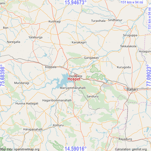
Hospet GPS coordinates[2]
15° 16' 10.344" North, 76° 23' 13.56" East
| Map corner | latitude | longitude |
|---|---|---|
| Upper-left | 15.94673°, | 75.68398° |
| Center: | 15.26954°, | 76.3871° |
| Lower-right: | 14.59016°, | 77.09023° |
| Map W x H: | 150.8×150.8 km | = 93.7×93.7mi |
| max Lat: | 34.9274° ⇑80.9% North |
| Hospet: | 15.26954° |
| min Lat: | ⇓19.1% South 8.09008° |
| min Long | Hospet | max Long |
| 68.82655° | 76.3871° | 96.81° |
| W 30.5%⇐ | ⇒69.5% E |
Elevation
Elevation of Hospet is 487 m = 1598 ft, and this is 191.4 m = 628 ft above average elevation for this country.
| Max E: |
3681 m = 12077 ft | 18.2% |
| Hospet | 487 m 1598 ft | |
| Avg. | 295.6 m = 970 ft | |
Min E: |
1 m = 3 ft | 81.8% |
See also: Hospet elevation on elevation.city.
Geographical zone
Hospet is located in North Torrid zone (between Equator and Tropic of Cancer). Distance of this Northern Tropic circle is 908.1 km =564.3 mi to North.| Distance of | km | miles | from Hospet |
|---|---|---|---|
| North Pole | 8309.2 | 5163.1 | to North |
| Arctic Circle | 5703.4 | 3543.9 | to North |
| Tropic Cancer | 908.1 | 564.3 | to North |
| Equator | 1697.8 | 1055 | to South |


Nearby cities:
15 places around Hospet: (largest is in red/bold)
• Bellary
59.3 km =36.8 mi,  103°
103°
• Gangāwati
23.6 km =14.7 mi,  40°
40°
• Hadagalli
56.2 km =34.9 mi,  240°
240°
• Hampi
10.7 km =6.6 mi,  47°
47°
• Kampli
27.4 km =17 mi,  56°
56°
• Kavalūr
47.6 km =29.6 mi,  272°
272°
• Koppal
26.3 km =16.3 mi,  288°
288°
• Kottūru
52.6 km =32.7 mi,  199°
199°
• Kushtagi
58 km =36 mi,  338°
338°
• Kūdligi
40.5 km =25.2 mi,  180°
180°
• Mundargi
54.4 km =33.8 mi,  262°
262°
• Munirābād
6.8 km =4.2 mi,  310°
310°
• Sandūr
26.6 km =16.5 mi,  139°
139°
• Tekkalakote
60.2 km =37.4 mi, 60°
• Yelbarga
55.6 km =34.5 mi, 313°
Sources, notices
• [Note1] Compared only with cities in India existing in our database
• [Src1] Map data: © OpenStreetMap contributors (CC-BY-SA)
• [Src2] Other city data from geonames.org with taken over terms of usage.
• [Src3] Geographical zone / Annual Mean Temperature by Robert A. Rohde @ Wikipedia
