Kottūru geodata
Kottūru (Karnataka) is a populated place; located in India in Asia/Kolkata (GMT+5.5) time zone. With population of 24,004 people, there are 1773 cities with bigger population in this country. Compared to other cities in India, 81.9% of cities are located further ↑North; 71.4% of cities are located further →East and 87.4% of cities have lower elevation than Kottūru. Note1


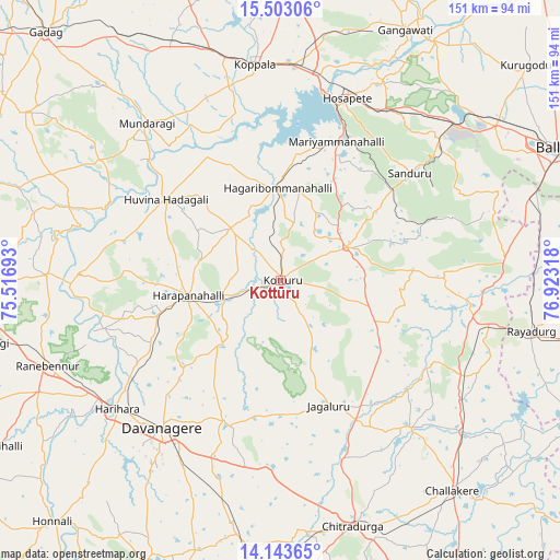
Kottūru GPS coordinates[2]
14° 49' 27.912" North, 76° 13' 12.18" East
| Map corner | latitude | longitude |
|---|---|---|
| Upper-left | 15.50306°, | 75.51693° |
| Center: | 14.82442°, | 76.22005° |
| Lower-right: | 14.14365°, | 76.92318° |
| Map W x H: | 151.2×151.2 km | = 94×94mi |
| max Lat: | 34.9274° ⇑81.9% North |
| Kottūru: | 14.82442° |
| min Lat: | ⇓18.1% South 8.09008° |
| min Long | Kottūru | max Long |
| 68.82655° | 76.22005° | 96.81° |
| W 28.6%⇐ | ⇒71.4% E |
Elevation
Elevation of Kottūru is 585 m = 1919 ft, and this is 289.4 m = 949 ft above average elevation for this country.
| Max E: |
3681 m = 12077 ft | 12.6% |
| Kottūru | 585 m 1919 ft | |
| Avg. | 295.6 m = 970 ft | |
Min E: |
1 m = 3 ft | 87.4% |
See also: India elevation on elevation.city.
Geographical zone
Kottūru is located in North Torrid zone (between Equator and Tropic of Cancer). Distance of this Northern Tropic circle is 957.6 km =595 mi to North.| Distance of | km | miles | from Kottūru |
|---|---|---|---|
| North Pole | 8358.7 | 5193.9 | to North |
| Arctic Circle | 5752.9 | 3574.7 | to North |
| Tropic Cancer | 957.6 | 595 | to North |
| Equator | 1648.3 | 1024.2 | to South |


Nearby cities:
15 places around Kottūru: (largest is in red/bold)
• Davangere
50.7 km =31.5 mi,  218°
218°
• Hadagalli
37.9 km =23.5 mi,  305°
305°
• Hampi
62.4 km =38.8 mi,  24°
24°
• Harihar
56.3 km =35 mi,  232°
232°
• Harpanahalli
25.2 km =15.7 mi,  260°
260°
• Hospet
52.6 km =32.7 mi, 19°
• Jagalūr
36.2 km =22.5 mi,  159°
159°
• Kavalūr
59.5 km =37 mi,  330°
330°
• Koppal
58.3 km =36.2 mi,  353°
353°
• Kūdligi
19.9 km =12.4 mi,  63°
63°
• Mundargi
55.8 km =34.7 mi,  319°
319°
• Munirābād
55.4 km =34.4 mi,  13°
13°
• Māyakonda
61.3 km =38.1 mi,  193°
193°
• Rānībennur
67.4 km =41.9 mi,  250°
250°
• Sandūr
45.6 km =28.3 mi,  50°
50°
Sources, notices
• [Note1] Compared only with cities in India existing in our database
• [Src1] Map data: © OpenStreetMap contributors (CC-BY-SA)
• [Src2] Other city data from geonames.org with taken over terms of usage.
• [Src3] Geographical zone / Annual Mean Temperature by Robert A. Rohde @ Wikipedia
