Yelbarga geodata
Yelbarga (Karnataka) is a populated place; located in India in Asia/Kolkata (GMT+5.5) time zone. With population of 12,023 people, there are 2737 cities with bigger population in this country. Compared to other cities in India, 79.1% of cities are located further ↑North; 73.6% of cities are located further →East and 88.6% of cities have lower elevation than Yelbarga. Note1


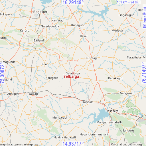
Yelbarga GPS coordinates[2]
15° 36' 55.62" North, 76° 0' 42.624" East
| Map corner | latitude | longitude |
|---|---|---|
| Upper-left | 16.29149°, | 75.30872° |
| Center: | 15.61545°, | 76.01184° |
| Lower-right: | 14.93717°, | 76.71497° |
| Map W x H: | 150.6×150.6 km | = 93.6×93.6mi |
| max Lat: | 34.9274° ⇑79.1% North |
| Yelbarga: | 15.61545° |
| min Lat: | ⇓20.9% South 8.09008° |
| min Long | Yelbarga | max Long |
| 68.82655° | 76.01184° | 96.81° |
| W 26.4%⇐ | ⇒73.6% E |
Elevation
Elevation of Yelbarga is 604 m = 1982 ft, and this is 308.4 m = 1012 ft above average elevation for this country.
| Max E: |
3681 m = 12077 ft | 11.4% |
| Yelbarga | 604 m 1982 ft | |
| Avg. | 295.6 m = 970 ft | |
Min E: |
1 m = 3 ft | 88.6% |
See also: India elevation on elevation.city.
Geographical zone
Yelbarga is located in North Torrid zone (between Equator and Tropic of Cancer). Distance of this Northern Tropic circle is 869.6 km =540.3 mi to North.| Distance of | km | miles | from Yelbarga |
|---|---|---|---|
| North Pole | 8270.8 | 5139.2 | to North |
| Arctic Circle | 5664.9 | 3520 | to North |
| Tropic Cancer | 869.6 | 540.3 | to North |
| Equator | 1736.3 | 1078.9 | to South |


Nearby cities:
15 places around Yelbarga: (largest is in red/bold)
• Bādāmi
48.9 km =30.4 mi,  312°
312°
• Gadag
45.9 km =28.5 mi,  243°
243°
• Gadag-Betageri
47.8 km =29.7 mi, 242°
• Gajendragarh
14.2 km =8.8 mi,  341°
341°
• Guledagudda
53.9 km =33.5 mi,  333°
333°
• Hospet
55.6 km =34.5 mi,  133°
133°
• Hungund
49.9 km =31 mi,  5°
5°
• Ilkal
39.7 km =24.7 mi,  15°
15°
• Kavalūr
37.1 km =23.1 mi,  191°
191°
• Koppal
33.7 km =20.9 mi,  152°
152°
• Kushtagi
24.8 km =15.4 mi,  50°
50°
• Mundargi
47.5 km =29.5 mi,  196°
196°
• Munirābād
48.8 km =30.3 mi, 134°
• Naregal
22.3 km =13.9 mi,  257°
257°
• Ron
31.2 km =19.4 mi,  287°
287°
Sources, notices
• [Note1] Compared only with cities in India existing in our database
• [Src1] Map data: © OpenStreetMap contributors (CC-BY-SA)
• [Src2] Other city data from geonames.org with taken over terms of usage.
• [Src3] Geographical zone / Annual Mean Temperature by Robert A. Rohde @ Wikipedia
