Puttūr geodata
Puttūr (Karnataka) is a populated place; located in India in Asia/Kolkata (GMT+5.5) time zone. With population of 53,331 people, there are 833 cities with bigger population in this country. Compared to other cities in India, 87.6% of cities are located further ↑North; 80.9% of cities are located further →East and 68.5% of cities have higher elevation than Puttūr. Note1


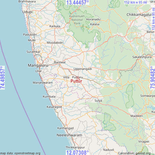
Puttūr GPS coordinates[2]
12° 45' 35.1" North, 75° 12' 6.084" East
| Map corner | latitude | longitude |
|---|---|---|
| Upper-left | 13.44457°, | 74.49857° |
| Center: | 12.75975°, | 75.20169° |
| Lower-right: | 12.07308°, | 75.90482° |
| Map W x H: | 152.5×152.5 km | = 94.8×94.8mi |
| max Lat: | 34.9274° ⇑87.6% North |
| Puttūr: | 12.75975° |
| min Lat: | ⇓12.4% South 8.09008° |
| min Long | Puttūr | max Long |
| 68.82655° | 75.20169° | 96.81° |
| W 19.1%⇐ | ⇒80.9% E |
Elevation
Elevation of Puttūr is 100 m = 328 ft, and this is 195.6 m = 642 ft below average elevation for this country.
| Max E: |
3681 m = 12077 ft | 68.5% |
| Avg. | 295.6 m = 970 ft | |
| Puttūr | 100 m = 328 ft | |
Min E: |
1 m = 3 ft | 31.5% |
See also: Puttūr elevation on elevation.city.
Geographical zone
Puttūr is located in North Torrid zone (between Equator and Tropic of Cancer). Distance of this Northern Tropic circle is 1187.2 km =737.7 mi to North.| Distance of | km | miles | from Puttūr |
|---|---|---|---|
| North Pole | 8588.3 | 5336.5 | to North |
| Arctic Circle | 5982.4 | 3717.3 | to North |
| Tropic Cancer | 1187.2 | 737.7 | to North |
| Equator | 1418.8 | 881.6 | to South |


Nearby cities:
15 places around Puttūr: (largest is in red/bold)
• Bantvāl
23.2 km =14.4 mi,  308°
308°
• Kānnangād
51.3 km =31.9 mi,  191°
191°
• Kārkala
55.4 km =34.4 mi,  335°
335°
• Kāsaragod
37.1 km =23.1 mi,  218°
218°
• Madikeri
69 km =42.9 mi,  122°
122°
• Mangalore
41.4 km =25.7 mi,  295°
295°
• Manjēshvar
34.4 km =21.4 mi,  261°
261°
• Mudgere
63.2 km =39.3 mi,  48°
48°
• Mūdbidri
40.8 km =25.4 mi,  326°
326°
• Mūlki
57.6 km =35.8 mi, 309°
• Nīlēshwar
56.1 km =34.9 mi, 187°
• Sakleshpur
66.3 km =41.2 mi,  72°
72°
• Somvārpet
72.6 km =45.1 mi,  104°
104°
• Sulya
29.9 km =18.6 mi,  137°
137°
• Ullal
37.3 km =23.2 mi,  277°
277°
Sources, notices
• [Note1] Compared only with cities in India existing in our database
• [Src1] Map data: © OpenStreetMap contributors (CC-BY-SA)
• [Src2] Other city data from geonames.org with taken over terms of usage.
• [Src3] Geographical zone / Annual Mean Temperature by Robert A. Rohde @ Wikipedia
