Pollachi geodata
Pollachi (Tamil Nadu) is a populated place; located in India in Asia/Kolkata (GMT+5.5) time zone. With population of 88,214 people, there are 505 cities with bigger population in this country. Compared to other cities in India, 94.5% of cities are located further ↑North; 63% of cities are located further →East and 66% of cities have lower elevation than Pollachi. Note1


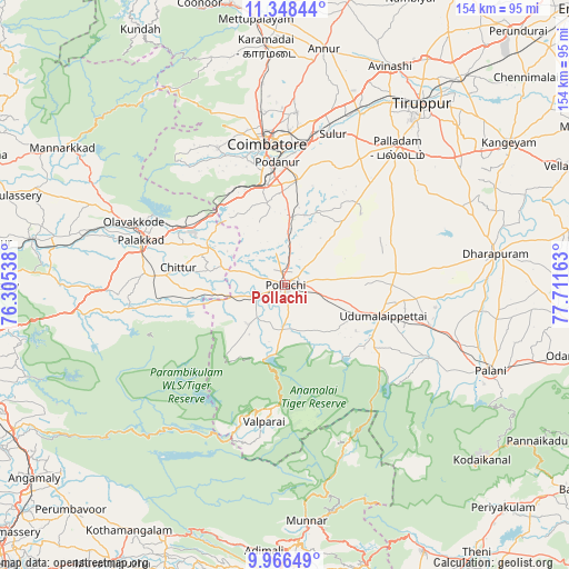
Pollachi GPS coordinates[2]
10° 39' 29.7" North, 77° 0' 30.6" East
| Map corner | latitude | longitude |
|---|---|---|
| Upper-left | 11.34844°, | 76.30538° |
| Center: | 10.65825°, | 77.0085° |
| Lower-right: | 9.96649°, | 77.71163° |
| Map W x H: | 153.7×153.7 km | = 95.5×95.5mi |
| max Lat: | 34.9274° ⇑94.5% North |
| Pollachi: | 10.65825° |
| min Lat: | ⇓5.5% South 8.09008° |
| min Long | Pollachi | max Long |
| 68.82655° | 77.0085° | 96.81° |
| W 37%⇐ | ⇒63% E |
Elevation
Elevation of Pollachi is 294 m = 965 ft, and this is 1.6 m = 5 ft below average elevation for this country.
| Max E: |
3681 m = 12077 ft | 34% |
| Avg. | 295.6 m = 970 ft | |
| Pollachi | 294 m = 965 ft | |
Min E: |
1 m = 3 ft | 66% |
See also: Pollachi elevation on elevation.city.
Geographical zone
Pollachi is located in North Torrid zone (between Equator and Tropic of Cancer). Distance of Equator is 1185.1 km =736.4 mi to South.| Distance of | km | miles | from Pollachi |
|---|---|---|---|
| North Pole | 8822 | 5481.7 | to North |
| Arctic Circle | 6216.1 | 3862.5 | to North |
| Tropic Cancer | 1420.8 | 882.8 | to North |
| Equator | 1185.1 | 736.4 | to South |


Nearby cities:
15 places around Pollachi: (largest is in red/bold)
• Anamalais
11.6 km =7.2 mi,  224°
224°
• Chettipālaiyam
28.4 km =17.6 mi,  6°
6°
• Chittūr
28.9 km =18 mi,  279°
279°
• Coimbatore
38.9 km =24.2 mi,  353°
353°
• Dhali
25.6 km =15.9 mi,  129°
129°
• Irugūr
40.4 km =25.1 mi, 8°
• Madukkarai
27.9 km =17.3 mi, 349°
• Periyanegamam
14 km =8.7 mi,  47°
47°
• Periyapatti
30.7 km =19.1 mi,  68°
68°
• Perūr
36.8 km =22.9 mi,  343°
343°
• Pālghāt
40.8 km =25.4 mi,  288°
288°
• Singānallūr
38 km =23.6 mi,  3°
3°
• Udumalaippettai
27.3 km =17 mi,  106°
106°
• Valparai
37.4 km =23.2 mi,  189°
189°
• Vettaikkaranpudur
14.9 km =9.3 mi, 224°
Sources, notices
• [Note1] Compared only with cities in India existing in our database
• [Src1] Map data: © OpenStreetMap contributors (CC-BY-SA)
• [Src2] Other city data from geonames.org with taken over terms of usage.
• [Src3] Geographical zone / Annual Mean Temperature by Robert A. Rohde @ Wikipedia
