Udumalaippettai geodata
Udumalaippettai (Tamil Nadu) is a populated place; located in India in Asia/Kolkata (GMT+5.5) time zone. With population of 58,571 people, there are 752 cities with bigger population in this country. Compared to other cities in India, 94.7% of cities are located further ↑North; 60.6% of cities are located further →East and 73.2% of cities have lower elevation than Udumalaippettai. Note1


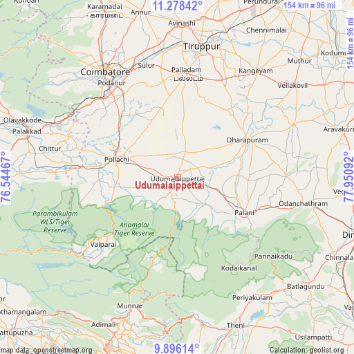
Udumalaippettai GPS coordinates[2]
10° 35' 17.016" North, 77° 14' 52.044" East
| Map corner | latitude | longitude |
|---|---|---|
| Upper-left | 11.27842°, | 76.54467° |
| Center: | 10.58806°, | 77.24779° |
| Lower-right: | 9.89614°, | 77.95092° |
| Map W x H: | 153.7×153.7 km | = 95.5×95.5mi |
| max Lat: | 34.9274° ⇑94.7% North |
| Udumalaippettai: | 10.58806° |
| min Lat: | ⇓5.3% South 8.09008° |
| min Long | Udumalaippettai | max Long |
| 68.82655° | 77.24779° | 96.81° |
| W 39.4%⇐ | ⇒60.6% E |
Elevation
Elevation of Udumalaippettai is 363 m = 1191 ft, and this is 67.4 m = 221 ft above average elevation for this country.
| Max E: |
3681 m = 12077 ft | 26.8% |
| Udumalaippettai | 363 m 1191 ft | |
| Avg. | 295.6 m = 970 ft | |
Min E: |
1 m = 3 ft | 73.2% |
See also: Udumalaippettai elevation on elevation.city.
Geographical zone
Udumalaippettai is located in North Torrid zone (between Equator and Tropic of Cancer). Distance of Equator is 1177.3 km =731.5 mi to South.| Distance of | km | miles | from Udumalaippettai |
|---|---|---|---|
| North Pole | 8829.8 | 5486.6 | to North |
| Arctic Circle | 6223.9 | 3867.4 | to North |
| Tropic Cancer | 1428.6 | 887.7 | to North |
| Equator | 1177.3 | 731.5 | to South |


Nearby cities:
15 places around Udumalaippettai: (largest is in red/bold)
• Anamalais
34.3 km =21.3 mi,  269°
269°
• Ayakudi
36.6 km =22.7 mi,  114°
114°
• Chettipālaiyam
42.8 km =26.6 mi,  327°
327°
• Dhali
10.8 km =6.7 mi,  217°
217°
• Dharapuram
35.3 km =21.9 mi,  61°
61°
• Kumaralingam
15.7 km =9.8 mi,  134°
134°
• Kīranūr
27.9 km =17.3 mi,  88°
88°
• Marayur
35.9 km =22.3 mi,  195°
195°
• Palani
33.6 km =20.9 mi,  117°
117°
• Palladam
45.1 km =28 mi,  5°
5°
• Periyanegamam
23.4 km =14.5 mi,  317°
317°
• Periyapatti
19.1 km =11.9 mi, 7°
• Pollachi
27.3 km =17 mi,  286°
286°
• Valparai
43.5 km =27 mi,  228°
228°
• Vettaikkaranpudur
36.7 km =22.8 mi, 265°
Sources, notices
• [Note1] Compared only with cities in India existing in our database
• [Src1] Map data: © OpenStreetMap contributors (CC-BY-SA)
• [Src2] Other city data from geonames.org with taken over terms of usage.
• [Src3] Geographical zone / Annual Mean Temperature by Robert A. Rohde @ Wikipedia
