Palāsbāri geodata
Palāsbāri (Assam) is a populated place; located in India in Asia/Kolkata (GMT+5.5) time zone. With population of 4,713 people, there are 3354 cities with bigger population in this country. Compared to other cities in India, 71.3% of cities are located further ↓South; 96.5% of cities are located further ←West and 78.9% of cities have higher elevation than Palāsbāri. Note1


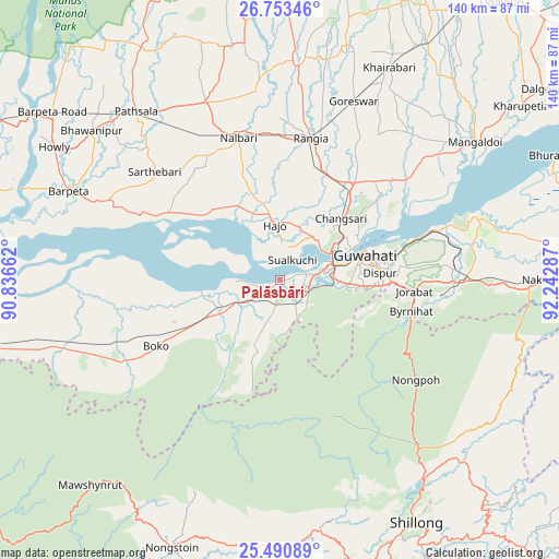
Palāsbāri GPS coordinates[2]
26° 7' 25.968" North, 91° 32' 23.064" East
| Map corner | latitude | longitude |
|---|---|---|
| Upper-left | 26.75346°, | 90.83662° |
| Center: | 26.12388°, | 91.53974° |
| Lower-right: | 25.49089°, | 92.24287° |
| Map W x H: | 140.4×140.4 km | = 87.2×87.2mi |
| max Lat: | 34.9274° ⇑28.7% North |
| Palāsbāri: | 26.12388° |
| min Lat: | ⇓71.3% South 8.09008° |
| min Long | Palāsbāri | max Long |
| 68.82655° | 91.53974° | 96.81° |
| W 96.5%⇐ | ⇒3.5% E |
Elevation
Elevation of Palāsbāri is 52 m = 171 ft, and this is 243.6 m = 799 ft below average elevation for this country.
| Max E: |
3681 m = 12077 ft | 78.9% |
| Avg. | 295.6 m = 970 ft | |
| Palāsbāri | 52 m = 171 ft | |
Min E: |
1 m = 3 ft | 21.1% |
See also: India elevation on elevation.city.
Geographical zone
Palāsbāri is located in North temperate zone (between Tropic of Cancer and the Arctic Circle). Distance of this Northern Tropic circle is 298.8 km =185.7 mi to South.| Distance of | km | miles | from Palāsbāri |
|---|---|---|---|
| North Pole | 7102.4 | 4413.2 | to North |
| Arctic Circle | 4496.5 | 2794 | to North |
| Tropic Cancer | 298.8 | 185.7 | to South |
| Equator | 2904.7 | 1804.9 | to South |


Nearby cities:
15 places around Palāsbāri: (largest is in red/bold)
• Barpeta
57.6 km =35.8 mi,  292°
292°
• Barpeta Road
70.8 km =44 mi,  306°
306°
• Dispur
26.1 km =16.2 mi,  87°
87°
• Guwahati
21.6 km =13.4 mi,  71°
71°
• Howli
64.9 km =40.3 mi,  300°
300°
• Hājo
13.6 km =8.5 mi,  353°
353°
• Mairang
63.3 km =39.3 mi,  171°
171°
• Mangaldai
60.4 km =37.5 mi,  54°
54°
• Mushalpur
51.9 km =32.2 mi, 347°
• Nongpoh
41.7 km =25.9 mi,  126°
126°
• Nongstoin
72.9 km =45.3 mi,  202°
202°
• North Guwāhāti
19.8 km =12.3 mi, 65°
• Rangia
36.9 km =22.9 mi,  11°
11°
• Shillong
70.6 km =43.9 mi,  150°
150°
• Soalkuchi
5.8 km =3.6 mi,  32°
32°
Sources, notices
• [Note1] Compared only with cities in India existing in our database
• [Src1] Map data: © OpenStreetMap contributors (CC-BY-SA)
• [Src2] Other city data from geonames.org with taken over terms of usage.
• [Src3] Geographical zone / Annual Mean Temperature by Robert A. Rohde @ Wikipedia
